Parkers Crossroads in Henderson County, Tennessee — The American South (East South Central)
The Battle Begins
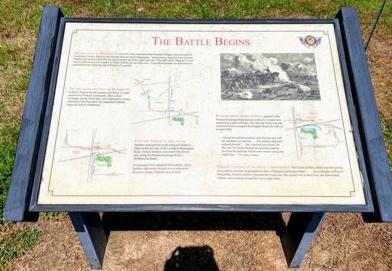
On the evening of December 30, Forrest's scouts ascertained that Dunham's Brigade was just north of Clarksburg. Forrest, knowing that General Sullivan was at Huntingdon, "determined to throw his force between Dunham and Sullivan and whip the former before the latter could intervene." That same night, Dunham's scouts reported that Forrest was camped at Union Church, just six miles west. A confident Dunham was determined to catch Forrest the following day at Parker's Crossroads.
The two forces met early on December 31 at Hicks' field on the McLemoresville Road, 1¼ mile northwest of Parker's Crossroads. After a short exchange, during which they were subjected to a heavy battering of shot and shell, the outgunned Federals began an orderly withdrawal.
Expecting Forrest to move south, Dunham deployed his troops along and behind a ridge on the east side of the Lexington-Huntingdon Road. Forrest, however, sent most of his forces east, along the Pleasant Exchange Road (Wildersville Road).
In response to this unexpected movement, which Dunham incorrectly thought was an attempt by Forrest to escape, Dunham moved north.
Dunham formed in line of battle parallel to the Pleasant Exchange Road and just north of a wooded area enclosed by a split-rail fence. The left side of the line was anchored on the Lexington-Huntingdon Road, the right on an open field.
"All had moved into position with alacrity and with the steadiness of veterans …The artillery had been ordered forward … but it had not yet arrived. By this time the enemy had got into position and the fire from his batteries had become intense along our whole line." Colonel Cyrus L. Dunham
Dunham's mistake put his men in a grim position. The Union artillery, which was late getting into position, was low on ammunition and, as Dunham would later report, "… was strikingly inefficient." Meanwhile, Forrest's artillery pounded the Union line. His cavalry was in their front and dismounted soldiers were working around the Union right flank.
Erected by Parker's Crossroads Battlefield Association.
Topics. This historical marker is listed in this topic list: War, US Civil. A significant historical date for this entry is December 30, 1852.
Location. 35° 47.634′ N, 88° 23.282′ W. Marker is in Parkers Crossroads, Tennessee, in Henderson County. Marker can be reached from Tennessee Route 22, 0.6 miles north of Interstate 40, on the right when traveling north. Marker is on the North Loop Walking Trail around 1700 feet from the start of the trail. This marker is found where the loop trail turns back toward the start.
The North Loop Walking Trail is at Tour Stop #1 (Parkers Crossroads City Park) of the Driving Tour. Touch for map. Marker is in this post office area: Wildersville TN 38388, United States of America. Touch for directions.
Other nearby markers. At least 8 other markers are within walking distance of this marker. Prelude to Battle/December 31, 1862—the Battle/Union and Confederate Forces (within shouting distance of this marker); Manning the Guns (within shouting distance of this marker); Civil War Artillery (within shouting distance of this marker); Confederate Horseholders (about 300 feet away, measured in a direct line); Forrest's Big Show (about 500 feet away); Fuller's Assault (about 500 feet away); "Give 'Em Hell" (about 500 feet away); A Panicked Stampede (about 600 feet away). Touch for a list and map of all markers in Parkers Crossroads.
Regarding The Battle Begins. The marker includes three battle maps described in the main text. A drawing shows a commander on horseback directing an artillery battery.
Additional keywords. Parkers Crossroads
Credits. This page was last revised on June 3, 2021. It was originally submitted on March 13, 2014, by David Graff of Halifax, Nova Scotia. This page has been viewed 469 times since then and 7 times this year. Photos: 1, 2. submitted on May 30, 2021, by Shane Oliver of Richmond, Virginia. 3. submitted on March 13, 2014, by David Graff of Halifax, Nova Scotia. • Bernard Fisher was the editor who published this page.


