South Beach in San Francisco City and County, California — The American West (Pacific Coastal)
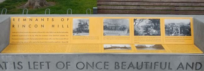
Remnants of Rincon Hill
Rincon Hill was first assaulted in 1869 when the notorious Second Street Cut dug a trench seventy feet deep along the width of fashionable Second Street from Bryant to Folsom, leaving houses teetering on the abyss. Gradually, in the 1880s and 90s, most of the larger houses became boarding houses with good addresses, or sanitariums, or Bohemian enclaves for artists and writers. The great fire of 1906 destroyed all of the homes on the hill. Some land holders put up post-fire flats for city workers. Others sold out to expanding city industries. Many lots stood vacant. In the 1930s the decision to locate the entrance to the Bay Bridge on the hill destroyed the working-class neighborhood that grew up after 1906. Construction of the Bay Bridge and its highway connections effectively erased any evidence of the day when Rincon Hill was the best address in San Francisco.
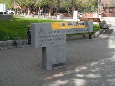
On the front of the podia
All that is left of once beautiful and imposing mansions crowned the brow of the cliff – Harles Stoddard, 1903
On the back of the podia
To each the city of his dreams – George Sterling, 1901
Erected by San Francisco Art Commission for the Waterfront Transportation Projects.
Topics. This historical marker is listed in this topic list: Notable Buildings. A significant historical year for this entry is 1869.
Location. 37° 46.951′ N, 122° 23.309′ W. Marker is in San Francisco, California, in San Francisco City and County. It is in South Beach. Marker is on The Embarcadero near Townsend Street, on the right when traveling south. Touch for map.
Photographed By Barry Swackhamer, March 20, 2014
2. Photograph detail from Remnants of Rincon Hill Marker
Photograph:
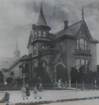
Top row, left
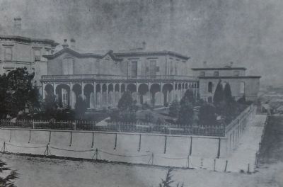
There were no typical Rincon Hill estates – for the Victorians, one’s house expressed individual personality. The Gothic style appealed to this ideal. A next door neighbor, Evelyn Breeze, remembers this Gothic home when she played there , a little girl: “When Jerome Lincoln lived there the estate had a black and white marble sidewalk, flanked at each end with two cast-iron lions couchant, which were great favorites with the young... In front was a fountain which played on festive occasions, and in the garden proper were statues of Apollo, Diana, two deer and dogs of varied kinds. There was a round summer house covered with ivy and honeysuckle where lunch was occasionally served. Near the stables, was an aviary where quail called to each other morning and evening. A large green parrot shrieked on his perch and gave military orders in French, much to the delight of the young.”
There were no typical Rincon Hill estates – for the Victorians, one’s house expressed individual personality. The Gothic style appealed to this ideal. A next door neighbor, Evelyn Breeze, remembers this Gothic home when she played there , a little girl: “When Jerome Lincoln lived there the estate had a black and white marble sidewalk, flanked at each end with two cast-iron lions couchant, which were great favorites with the young... In front was a fountain which played on festive occasions, and in the garden proper were statues of Apollo, Diana, two deer and dogs of varied kinds. There was a round summer house covered with ivy and honeysuckle where lunch was occasionally served. Near the stables, was an aviary where quail called to each other morning and evening. A large green parrot shrieked on his perch and gave military orders in French, much to the delight of the young.”
Other nearby markers. At least 8 other markers are within walking distance of this marker. Building the Seawall (within shouting distance of this marker); Townsend Street (about 300 feet away, measured in a direct line); The Alaska Packers (about 300 feet away); The Oriental Warehouse (about 300 feet away); Whaling Out of San Francisco (about 400 feet away); Fremont Street (about 400 feet away); Java House (about 500 feet away); Ghost Ship - Lydia (about 600 feet away). Touch for a list and map of all markers in San Francisco.
Also see . . . A History of Ever-changing Rincon Hill - SPUR. By 1852, San Francisco's overgrown mining camp era was rapidly disappearing. Many Forty-Niners asked their wives or sweethearts back home to join them... Many of these families lived in three- and four-room cottages in today's downtown area and nearby South of Market blocks. Well-to-do San Franciscans, of course, wanted substantial houses and stylish neighborhoods which, for a few, recalled their previous way of life back East and, for most others, showed off the money they had just won in the West. (Submitted on March 31, 2014, by Barry Swackhamer of Brentwood, California.)
Photographed By Barry Swackhamer, March 20, 2014
4. Photograph detail from Remnants of Rincon Hill Marker
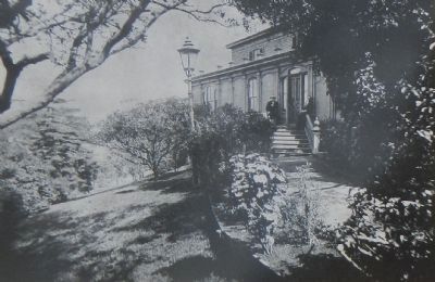
Photograph: Top row, center right
In 1879, William Babcock and his wife enjoy their garden from the porch of their comfortable home at #11 Essex, built in 1854. Lavish planting gave the illusion of a country estate, although First Street iron foundries were but a block away.
In 1879, William Babcock and his wife enjoy their garden from the porch of their comfortable home at #11 Essex, built in 1854. Lavish planting gave the illusion of a country estate, although First Street iron foundries were but a block away.
Photographed By Barry Swackhamer, March 20, 2014
5. Photograph detail from Remnants of Rincon Hill Marker
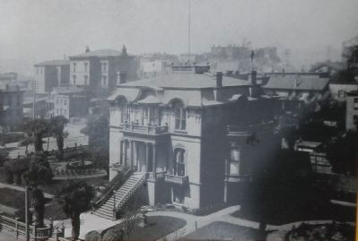
Photograph: Top row, right
Carefully manicured Victorian gardens of the 1880’s at the corner of Bryant and Second streets are the setting for the forty room spread of Peter Donahue, an Irish blacksmith turned capitalist.
Carefully manicured Victorian gardens of the 1880’s at the corner of Bryant and Second streets are the setting for the forty room spread of Peter Donahue, an Irish blacksmith turned capitalist.
Photographed By Barry Swackhamer, March 20, 2014
7. Photograph detail from Remnants of Rincon Hill Marker
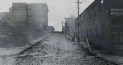
Photograph: Bottom row, right
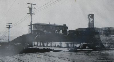
Guy Place ended at the edge of Babcock’s garden. By 1919 tenement flats had been built alongside industrial buildings, filling space left by the 1906 fire. The 1910 census revealed over-crowded conditions where European immigrants struggled to survive.
Guy Place ended at the edge of Babcock’s garden. By 1919 tenement flats had been built alongside industrial buildings, filling space left by the 1906 fire. The 1910 census revealed over-crowded conditions where European immigrants struggled to survive.
Credits. This page was last revised on February 7, 2023. It was originally submitted on March 31, 2014, by Barry Swackhamer of Brentwood, California. This page has been viewed 634 times since then and 33 times this year. Photos: 1, 2, 3, 4, 5, 6, 7, 8. submitted on March 31, 2014, by Barry Swackhamer of Brentwood, California. • Bill Pfingsten was the editor who published this page.
