Rye in Rockingham County, New Hampshire — The American Northeast (New England)
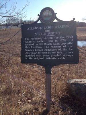
Atlantic Cable Station and Sunken Forest
Erected by New Hampshire Division of Historical Resources. (Marker Number 063.)
Topics and series. This historical marker is listed in these topic lists: Communications • Environment. In addition, it is included in the New Hampshire Historical Highway Markers series list. A significant historical year for this entry is 1874.
Location. 42° 59.584′ N, 70° 45.543′ W. Marker is in Rye, New Hampshire, in Rockingham County. Marker is on Ocean Boulevard (New Hampshire Route 1A), on the right when traveling north. Touch for map. Marker is in this post office area: Rye NH 03870, United States of America. Touch for directions.
Other nearby markers. At least 8 other markers are within 5 miles of this marker, measured as the crow flies. Isles Of Shoals (approx. one mile away); New Isles of Shoals Marker (approx. one mile away); Rye NH War Memorial (approx. 1.4 miles away); Key Facts about Pulpit Rock Tower (approx. 3.4 miles away); Pulpit Rock Fire Control Tower (approx. 3.4 miles away); Lafayette's Tour (approx. 4.8 miles away); 480 Portsmouth Avenue (approx. 4.8 miles away); Congregational Church (approx. 4.8 miles away). Touch for a list and map of all markers in Rye.
Credits. This page was last revised on June 16, 2016. It was originally submitted on March 22, 2012, by Rod Funston of Eastham, Massachusetts. This page has been viewed 1,191 times since then and 32 times this year. Last updated on June 19, 2014, by Kevin Craft of Bedford, Quebec. Photo 1. submitted on March 22, 2012, by Rod Funston of Eastham, Massachusetts. • Bill Pfingsten was the editor who published this page.
