Thompson's Station in Williamson County, Tennessee — The American South (East South Central)
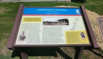
Thompson's Station
Prelude to Franklin
ó Hood's Campaign ó
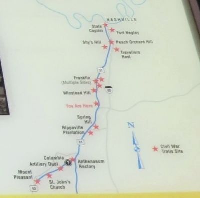
In September 1864, after Union Gen. William T. Sherman defeated Confederate Gen. John Bell Hood at Atlanta, Hood led the Army of Tennessee northwest against Shermanís supply lines. Rather than contest Shermanís “March to the Sea,” Hood moved north into Tennessee. Gen. John M. Schofield, detached from Shermanís army, delayed Hood at Columbia and Spring Hill before falling back to Franklin. The bloodbath there on November 30 crippled the Confederates, but they followed Schofield to the outskirts of Nashville and Union Gen. George H. Thomasís strong defenses. Hoodís campaign ended when Thomas crushed his army on December 15-16.
(main text)
On November 29, 1864, just one day before the Battle of Franklin, an action occurred here at Thompsonís Station that alarmed Union Gen. John M. Schofieldís army as it marched north toward Nashville from Spring Hill. For a time, Lt. Col. Daniel W. McCoy and the 175th Ohio Infantry had occupied ground near the railroad depot. Soon, however, Confederate Gen. Lawrence S. Roseís cavalry brigade from Gen. Nathan Bedford Forrestís command drove off the Ohio regiment, burned the bridge and depot, and attacked a train arriving from the south. The engineer backed hastily toward Spring Hill and spread the word, which raised concerns that the Federal escape route to Nashville had been blocked. By that afternoon, Rossís men also had possession of the Columbia Pike, but about sundown they withdrew toward Spring Hill to obtain further orders. After midnight, however, they returned to the station and attacked the head of the Federal wagon train. Union infantry arrived to drive Ross off near dawn, and the remainder of Schofieldís army slipped past Confederate Gen. John Bell Hoodís army, marched through Thompsonís Station, and escaped to Franklin.
(sidebar)
Another action was fought here on March 5, 1863, when Union Col. John Coburnís infantry and cavalry engaged Confederate Gen. Earl Van Dornís cavalry. Some of the fighting swirled around the nearby Thompson House now called Homestead Manor. Forrestís cavalrymen galloped in from the east, got behind some of the Union infantrymen on the other side of the road and cut off their retreat. Coburnís attack suddenly collapsed, and more than 1,000 Union soldiers surrendered. Just two months later, local physician George Peters murdered Van Dorn at Spring Hill, having discovered the general was having an affair with Peterís young wife.
(captions)
(lower left) Gen. Lawrence S. Ross Courtesy Texas Ranger Hall of Fame
(upper center) Postwar photograph of rebuilt Thompsonís Station - Courtesy Rick Warwick Collection
(lower left) Gen. Earl Van Dorn Library of Congress
Erected by Tennessee Civil War Trails.
Topics and series. This historical marker is listed in this topic list: War, US Civil. In addition, it is included in the Tennessee Civil War Trails series list. A significant historical month for this entry is September 1864.
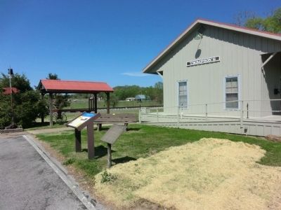
Location. 35° 48.008′ N, 86° 54.614′ W. Marker is in Thompson's Station, Tennessee, in Williamson County. Marker is at the intersection of Thompson's Station Road West and School Street, on the right when traveling west on Thompson's Station Road West. The marker is located at the Thompson's Station Depot. Touch for map. Marker is at or near this postal address: 1502 Thompsons Station Rd W, Thompsons Station TN 37179, United States of America. Touch for directions.
Other nearby markers. At least 8 other markers are within walking distance of this marker. Thompson's Station Train Depot (here, next to this marker); Thompson Station Bank (within shouting distance of this marker); A Deep Past, Rich Land (approx. 0.2 miles away); Early Settlers (approx. 0.3 miles away); Homestead Manor (approx. 0.3 miles away); Battle of Thompson's Station (approx. 0.4 miles away); Slavery at Thompson's Station (approx. 0.4 miles away); a different marker also named Battle of Thompson's Station (approx. 0.6 miles away). Touch for a list and map of all markers in Thompson's Station.
Credits. This page was last revised on June 16, 2016. It was originally submitted on July 6, 2014, by Don Morfe of Baltimore, Maryland. This page has been viewed 911 times since then and 32 times this year. Photos: 1, 2, 3, 4, 5. submitted on July 6, 2014, by Don Morfe of Baltimore, Maryland. • Bernard Fisher was the editor who published this page.


