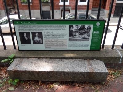
Tombs and Monuments
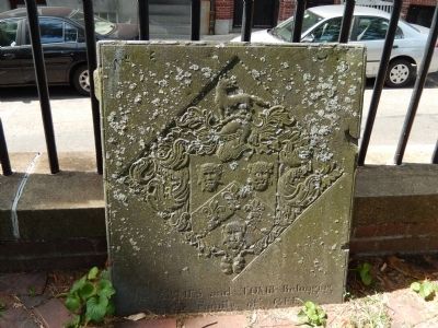
Throughout Copp's Hill Burying Ground are examples of tombs and monuments constructed to commemorate the dead. Table tombs or table-stones are elaborate markers of a grave's location. Usually there is a sepulcher underneath the marker holding the remains of multiple family members. One example is the Hutchinson/Lewis tomb (G-295.) It once contained members of the famous (and infamous) Hutchinson family of Boston. After royal Governor Hutchinson fled to London, the tomb was bought by a Mr. Lewis and it is his name inscribed on the face. Tombs were first granted and built in 1717-1718, and were constructed around the edges of the graveyard. They were large, cellar-like constructions with arched openings. Many family tombs, but others, were bought and rented to whomever paid for space.
The Gee Family Tomb
Peter Gee (c. 1608-1682), fisherman, bought land in Boston in 1668. His son, Joshua Gee (d. 1724), became a prosperous shipwright, owning a shipyard on the North End waterfront. He bought Tomb #3 around 1717. His son Joshua Gee Jr. (1698-1748) attended Harvard College (1717) and was the fourth minister of Second Church (1723-1748), succeeding the Mathers. Gee also maintained his father's shipbuilding business. His wealth is exemplified by the portraits of him and his second wife, Anna Gerrish, by painter John Smibert.
Builder
of the U.S.S. Constitution
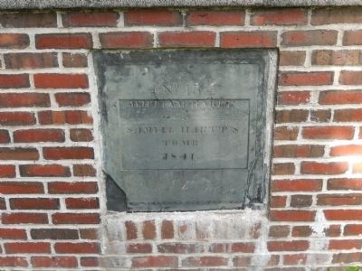
Edmund Hartt (1744-1824), shipbuilder, was born in Lynn, Massachusetts. In 1771, he married Elizabeth Clark and together had ten children. In 1786, Edmund and Elizabeth bought a shipyard on Commercial Street that had one building slip, a saw pit, and a blacksmith shop. In 1794, Hartt Shipyard won the contract to construct the U.S.S. Constitution, which was launched on October 21, 1797. The shipyard also produced U.S. naval ships Boston and Argus. The site of the Hartt Shipyard is now called Constitution Wharf and is the site of the U.S. Coast Guard Support Center. Edmund Hartt and family are buried in Tomb #55.
The Seamen's Tomb (D-1) was the idea of Phineas Stowe, pastor of the First Baptist Bethel Church in the North End. It is marked by a monument dedicated to "Seamen of All Nations" and was built from their contributions. There is also an unmarked City Tomb for Infants in Section D. Other monuments in Copp's Hill mark family tombs such as the Dupees (g-297) and Jarvis (A-385.)
Copp's Hill Facts
Below ground burials were outlawed in 1836, but tomb burials continued until 1968.
Gravestone carvers re-used old or unclaimed gravestones. Look at the back of the marker of Theodore James (d. 1813) (G-235) (towards the entrance on the right near the tree) to see the upside-down writing from an earlier carving!
Topics. This historical marker is listed in this topic list: Cemeteries & Burial Sites. A significant historical month for this entry is October 1712.
Location. 42° 22.015′ N, 71° 3.355′ W. Marker is in Boston, Massachusetts, in Suffolk County. It is in North End. Marker can be reached from Hull Street. Marker is within Copp's Hill Burying Ground. Touch for map. Marker is in this post office area: Boston MA 02113, United States of America. Touch for directions.
Other nearby markers. At least 8 other markers are within walking distance of this marker. Copp's Hill Burying Ground (a few steps from this marker); Welcome to Copp’s Hill Burying Ground (within shouting distance of this marker); a different marker also named Copp’s Hill Burying Ground (within shouting distance of this marker); Gravestone Art: Skulls, Wings, and Other Symbols (within shouting distance of this marker); Unusual Gravestones (within shouting distance of this marker); From Colonial Burying Ground to Victorian Park (within shouting distance of this marker); Copp’s Hill and the American Revolution (within shouting distance of this marker); Seventeenth Century Copp’s Hill (within shouting distance of this marker). Touch for a list and map of all markers in Boston.
Credits. This page was last revised on January 30, 2023. It was originally submitted on August 28, 2014, by Bill Pfingsten of Bel Air, Maryland. This page has been viewed 630 times since then and 34 times this year. Last updated on February 2, 2020, by Bruce Guthrie of Silver Spring, Maryland. Photos: 1, 2, 3. submitted on August 28, 2014, by Bill Pfingsten of Bel Air, Maryland. • Michael Herrick was the editor who published this page.


