Annapolis Royal in Annapolis County, Nova Scotia — The Atlantic Provinces (North America)
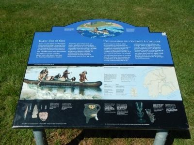
Early Use of Site
L’utilisation de l’endroit à l’origine

Photographed By Barry Swackhamer, June 17, 2014
1. Early Use of Site Marker
Captions (English / French): (top) Detail of the Fort Anne Heritage Tapestry depicting two Mi’kmaq arriving at the Port-Royal Habitation. / Détail de la tapisserie historique de Fort-Anne montrant deux Mi’kmaq lors de leur arrivée à l’Habitation de Port-Royal,; Visit our exhibit to find out more about the evolution of the site / Ne manquez pas de voir expositions pour en apprendre davantage sur l’évolution du lieu.; (Click on the image to enlarge it and read the center picture’s information on canoe travel); (bottom row) Aboriginal artifacts show that the ancestors of the Mi’kmaq camped here for over 3,000 years. / Les artefacts autochtones révèlent que les site a été occupé par les Mi’kmaq et leur ancêtres pendant plus de 3 000 ans.; Fragments of an earthenware cooking pot typical of early 1600s English sites, Archaeological evidence suggests this artifact came from Sir William Alexander’s Scot settlement. / Fragments d’une marmite en terre cuite semblables à ceux trouvés sur les sites occupés des années 1600. Les données archéologiques laissent supposer que cet artefact vient de l’établissement écossais de sir William Alexander.; Venetian-style glass fragment, probably from a wine glass. Archaeological evidence suggests this artifact came from d’Aulney’s settlement. / Fragments de verre de type vénitien provenant sans doute d’un verre à vin. Les données archéologiques laissent supposer que cet artefact vient de l’établissement de d’Aulnay.
Before you, the Allain and Annapolis rivers meet, creating a stopping place used by travelers for many centuries. The Annapolis River makes access to the site easy, while the natural rise of land provides a good view downstream.
The Mi’kmaw (sic) people used this site for over 3,000 years. Men from the Port-Royal Habitation, located downriver, grew wheat here and built a gristmill on the Allain River in the early 1600s. In 1629, Sir William Alexander chose this site for a Scottish settlement. Later, in 1636, Charles de Menou d’Aulnay relocated his settlement here from LaHave. A succession of forts protected settlements here for over 200 years.
French
Devant vous, les rivières Allain et Annapolis se rencontrent à un point qui sert d’escale aux voyageurs pendant de nombreux siècles. La rivière Annapolis facilite l’accès à l’endorit et l’élévation naturelle de la terre fournit une bonne vue en aval.
Les Mi’kmaq font escale ici pendant plus de 3 000 ans. Des hommes de l’Habitation de Port-Royal, située en aval, cultivent ici le blé et ils construisent un moulin à farine sur la rivière Allain au début des années 1600. En 1629, sir William Alexander choisit ce endroit pour y établir de Écossais. Plus tard, en 1636, Charles de Menou d’Aulnay part de LaHave avec ses colons pour venir s’y établir. Ainsi, pendant plus de 200 ans, plusieurs fort se seccèdent ici afin de protéger les établissements.
Erected by Parks Canada.
Topics. This historical marker is listed in these topic lists: Native Americans • Settlements & Settlers. A significant historical year for this entry is 1629.
Location. 44° 44.456′ N, 65° 31.223′ W. Marker is in Annapolis Royal, Nova Scotia, in Annapolis County. Marker is on St. George Street close to St. Anthony Street, on the left when traveling west. Touch for map. Marker is at or near this postal address: 323 St George Street, Annapolis Royal NS B0S, Canada. Touch for directions.
Other nearby markers. At least 8 other markers are within walking distance of this marker. Charles Fort / Le fort Charles (a few steps from this marker); Samuel Vetch (within shouting distance of this marker); Acadian Dykeland (within shouting distance of this marker); Jean Paul Mascarene (within shouting distance of this marker); The Flag Bastion (about 90 meters away, measured in a direct line); The Black Hole / Le cachot (about 90 meters away); Fort Anne, a Bastioned Fort (about 120 meters away); Port-Royal (about 120 meters away). Touch for a list and map of all markers in Annapolis Royal.
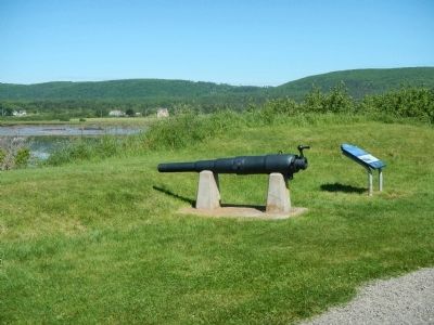
More about this marker. This marker is located on the grounds of Fort Anne National Historic Site.
Also see . . . Mi'kmaq - Wikipedia. The Mi'kmaq are a First Nations people, indigenous to Canada's Maritime Provinces and the Gaspé Peninsula of Quebec. They call this region Mi'kma'ki. (Submitted on November 2, 2014, by Barry Swackhamer of Brentwood, California.)
Credits. This page was last revised on June 16, 2016. It was originally submitted on November 2, 2014, by Barry Swackhamer of Brentwood, California. This page has been viewed 434 times since then and 9 times this year. Photos: 1, 2. submitted on November 2, 2014, by Barry Swackhamer of Brentwood, California. • Andrew Ruppenstein was the editor who published this page.
