Annapolis Royal in Annapolis County, Nova Scotia — The Atlantic Provinces (North America)
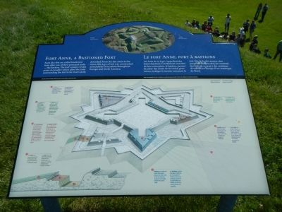
Fort Anne, a Bastioned Fort
Le Fort Anne, fort à bastions
Inscription.
English
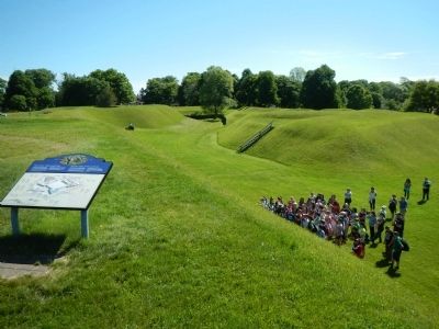
Forts like this are called bastioned forts after one other principal pars - the bastion. The fort’s shape creates areas of crossfire which allow the land surrounding the fort to be moere easily defended. From the late 1600s to the 1800s, this type of fort was constructed at hundreds of locations throughout Europe and North America.
French
Les forts de ce type s’appellent des forts à bastions. Cet élément essentiel de leur conception, le bastion, permet de créer des zones de tir croisé, pour mieux protéger les terrain entourant le fort. Dès la fin des années 1600 jusqu’aux années 1800, on construit des forts de ce type à des centaines d’endroits en Europe et en Amérique de Nord.
Click on the image to this marker to enlarge it and identify the points below. English / French.
(1) A ravelin is a triangular defensive work built in the ditch in front of the curtain wall. / Un demi-lune est un ouvrage de défense triangulaire construit dans le fossé en face de la courtine.
(2) The glacis is a slope of land approaching a fortification which is shaped so all areas are exposed to cannon fire. / Le glacis est un terrain en pente aux abords des fortifications. Les glacis sont conçus pour que tous les espaces soient exposés au tir des canons.
(3) The covered way is a kind of road that runs around the ditch and is protected by the slope of the glacis. Often an earthen step was located on the covered way for soldiers to stand on and fire down the glacis. / Le chemin couvert est un chemin qui longe le fossé et qui est protégé par la pente du glacis. On y retrouve souvent une espèce de marche sur laquelle les soldats peuvent se tenir pour faire feu le long du glacis.
(4) The ditch is a trench around the fortification that slows the advance of attacking troops. / Le fossé est un tranchée profonde entrant les fortifications. Le fossé sert à relented l’avancée des troupes d’attaque.
(5) Bastions are defensive works that project beyond the main walls of the fort allowing troops to more easily defend the curtain wall. / Les bastions sont des ouvrages de défense qui se portent à l’extérieur des murs principaux du fort et qui permettent aux soldats de défendre plus facilement les courtines. (6) Crossfire occurs when one place is shot upon from two locations. This is extremely hazardous for troops in a battlefield. / The tir croisé se produit lorsque l’on tire sur une même cible à partir de deux points. Il s’agit d’une situation très dangereuse pour des soldats au champ de batalle.
(7) A curtain wall is a long, defensive wall that joins two bastions. / Une courtine est un mur long qui sert de défense et qui joint deux bastions.
Erected by Parks Canada.
Topics. This historical marker is listed in these topic lists: Forts and Castles • War, French and Indian. A significant historical year for this entry is 1600.
Location. 44° 44.462′ N, 65° 31.133′ W. Marker is in Annapolis Royal, Nova Scotia, in Annapolis County. Marker can be reached from St. George Street close to St. Anthony Street, on the left when traveling west. Touch for map. Marker is at or near this postal address: 323 St George Street, Annapolis Royal NS B0S, Canada. Touch for directions.
Other nearby markers. At least 8 other markers are within walking distance of this marker. Jean Paul Mascarene (within shouting distance of this marker); Acadian Dykeland (within shouting distance of this marker); Captures of Port Royal (within shouting distance of this marker); Daniel Auger de Subercase (within shouting distance of this marker); The Black Hole / Le cachot (about 90 meters away, measured in a direct line); Duvivier Attack (about 90 meters away); The Flag Bastion (about 90 meters away); Samuel Vetch (about 90 meters away). Touch for a list and map of all markers in Annapolis Royal.
More about this marker. This marker is located on the grounds of Fort Anne National Historic Site.
Also see . . . Fort Anne - Wikipedia

Photographed By Barry Swackhamer, June 17, 2014
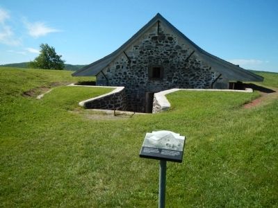
3. Powder Magazine
Built by the French in 1708, the Powder Magazine was used to store the fort’s gunpowder. It is the only surviving building from the French period. / Construite par les Français en 1708, le poudrière sert à entreposer la poudre à canon utilisée au fort. Il s’agit du seul bâtiment qui reste de l’époque de la construction par les Français.
Credits. This page was last revised on August 16, 2017. It was originally submitted on November 3, 2014, by Barry Swackhamer of Brentwood, California. This page has been viewed 551 times since then and 9 times this year. Photos: 1, 2, 3, 4. submitted on November 3, 2014, by Barry Swackhamer of Brentwood, California. • Andrew Ruppenstein was the editor who published this page.


