Near Carlin in Elko County, Nevada — The American Mountains (Southwest)
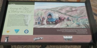
Leaving the River, Climbing the Hill
Carlin

Photographed By Barry Swackhamer, August 29, 2014
1. Leaving the River, Climbing the Hill Marker
Captions: (top, right) “Our road this afternoon is up a steep mountain side seven miles long; the steepest, roughest, and most desolate road that can be imagined. The mountains that border this valley are looking very old… It makes a man lonesome and homesick to contemplate their forlorn, deserted, and uncanny appearance…” John Hawkins, August 5, 1852.
(bottom strip, left to right) Grease Bucket - An essential requirement for the overland journey. The axles of the wagons required frequent lubrication to offset the effects of trail dust on moving parts; Wedge, Glut & Maul - These woodworking tools were taken on the journey for splitting logs at the emigrants new homes in California.; Prairie Schooner - These sturdy wagons were the primary vehicles of the trail west. They served as conveyances for both cargo and people and as shelters from the elements.
(bottom strip, left to right) Grease Bucket - An essential requirement for the overland journey. The axles of the wagons required frequent lubrication to offset the effects of trail dust on moving parts; Wedge, Glut & Maul - These woodworking tools were taken on the journey for splitting logs at the emigrants new homes in California.; Prairie Schooner - These sturdy wagons were the primary vehicles of the trail west. They served as conveyances for both cargo and people and as shelters from the elements.
After leaving the Humboldt River near here, emigrants had to travel 18 steep miles — following the approximate route of I-80 up over ridges and down canyons — until they reached the Humboldt again at Gravelly Ford. This short hop of 18 miles can be traveled in 20 minutes or so today, but it the 1850s and 1860s it was one more hardship for teams and trekkers, out of many already experienced and many more to come. When the California bound emigrants reached this point it was usually during the hot, dry summer months of July and August. By this time they had completed three quarters of their 2,000-mile trek between the Missouri River and California and had been traveling for over four months… but the worst part was still ahead of them.
Erected by Department of the Interior, Bureau of Land Management & State of Nevada.
Topics. This historical marker is listed in these topic lists: Roads & Vehicles • Settlements & Settlers.
Location. 40° 42.046′ N, 116° 7.859′ W. Marker is near Carlin, Nevada, in Elko County. Marker is on Tomera Road near Nevada Route 278, on the right when traveling west. Touch for map. Marker is at or near this postal address: 100 Tomera Road, Carlin NV 89822, United States of America. Touch for directions.
Other nearby markers. At least 5 other markers are within 8 miles of this marker, measured as the crow flies. California Trail — Hot Springs (a few steps from this marker); Carlin (approx. 0.9 miles away); Carlin Canyon (approx. 6.1 miles away); California Trail - Carlin Canyon (approx. 6.6 miles away); Palisade (approx. 7.3 miles away).

Photographed By Barry Swackhamer, August 29, 2014
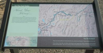
3. About Your Journey
Whichever direction your travels take you, you’re going to have a similar experience to what the California-bound emigrants had. You’re going to see the same country, except for the towns and the ranch meadows. The big difference though, is that you’ll be traveling at a much faster pace. From here, you can be in California in a few hours. For the emigrants, it was as much as a month’s journey. As you drive and look at the country, think about those people who plodded along day after day through the thick alkali dust and sand — headed toward dreams of gold or a new life.
Captions: (bottom left) The California Trail had its beginnings at several points along the Missouri River, and included several variant routes across the Great Basin and over the Sierra Nevada mountains. With the completion of the transcontinental railroad in 1869, most travelers made the journey by rail.; (bottom right) You’re Invited! There are many California Trail sites like this one, spread across Nevada. They’re marked on this map. As you stop at these sites, you’ll learn about what happened to these emigrants as they traveled across the Great Basin. Be sure to visit the California Trail Interpretive Center just west of Elko, Nevada.
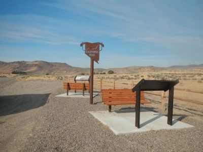
This plaque is found at each of the BLM California Trail Interpretative Sites.
Credits. This page was last revised on June 16, 2016. It was originally submitted on March 3, 2015, by Barry Swackhamer of Brentwood, California. This page has been viewed 356 times since then and 21 times this year. Photos: 1, 2, 3. submitted on March 3, 2015, by Barry Swackhamer of Brentwood, California. • Syd Whittle was the editor who published this page.
