Old Town in Alexandria, Virginia — The American South (Mid-Atlantic)
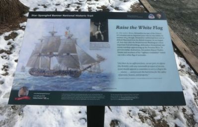
Raise the White Flag
Star-Spangled Banner National Historic Trail
— War of 1812 —
In the early 1800s Alexandria was part of the District of Columbia and an important port with its own militia. In summer 1814, though, Alexandria’s militia had been sent to defend Maryland from the British invasion. So on August 28, four days after the British burned Washington’s most important federal buildings, defenseless Alexandrians saw enemy warships approaching up the Potomac River. To prevent similar destruction, Alexandria Mayor Charles Simms and members of his “vigilance committee” rowed out with a white flag of surrender.
“(As) there be no sufficient force, on our part, to oppose (the British), with any reasonable prospect of success, (you) should appoint a committee to carry a flag to the…enemy…and procure the best terms for the safety of persons, houses, and property.” Alexandria vigilance committee’s recommendation to the city’s Common Council.
(Sidebar:)
In the summer of 1814 the United States had been at war with Great Britain for two years. Battlefronts had erupted from the Great Lakes to the Gulf of Mexico. On August 24, following their victory over the Americans at the Battle of Bladensburg, Maryland, British troops marched on Washington with devastating results.
The Star-Spangled Banner National Historic Trail reveals sites of War of 1812 in Washington, DC, Virginia, and Maryland. Visit ChesapeakeExplorerApp.com or download the Chesapeake Explorer app.
(Caption:)
HMS Euryalus, commanded by Captain Charles Napier (above), was one of seven British vessels carrying a total of 128 guns that sailed up the Potomac to Alexandria. Oil by Thomas Musgrave Fox, National Maritime Museum (UK)
Erected by National Park Service, U.S. Department of the Interior.
Topics. This historical marker is listed in these topic lists: War of 1812 • Waterways & Vessels. A significant historical year for this entry is 1814.
Location. 38° 48.223′ N, 77° 2.382′ W. Marker is in Alexandria, Virginia. It is in Old Town. Marker is on The Strand south of King Street, on the left when traveling south. The marker is located in Waterfront Park. Touch for map. Marker is in this post office area: Alexandria VA 22314, United States of America. Touch for directions.
Other nearby markers. At least 8 other markers are within walking distance of this marker. Pioneer Mill (here, next to this marker); The Domestic Slave Trade (within shouting distance of this marker); Waterfront Walk (within shouting distance of this marker); River Ferries (within shouting distance of this marker); The History of the Pineapple (within shouting distance of this marker); George Henry, Enslaved Ship Captain (within shouting distance of this marker); Foot of King Street (within shouting distance of this marker); Alexandria Archaeology Museum (within shouting distance of this marker). Touch for a list and map of all markers in Alexandria.
Also see . . .
1. Stars-Spangled Banner National Historic Trail. National Park Service (Submitted on March 5, 2015.)
2. Stars-Spangled Banner National Historic Trail - DC, MD, VA. National Park Service (Submitted on March 5, 2015.)
3. Cultural Tourism DC. (Submitted on March 5, 2015.)
Credits. This page was last revised on March 16, 2023. It was originally submitted on March 5, 2015, by Don Morfe of Baltimore, Maryland. This page has been viewed 811 times since then and 38 times this year. Photos: 1, 2, 3, 4, 5, 6. submitted on March 5, 2015, by Don Morfe of Baltimore, Maryland. • Bernard Fisher was the editor who published this page.


