Shelbyville in Bedford County, Tennessee — The American South (East South Central)
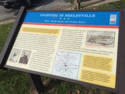
Fighting in Shelbyville
Rain, Muddy Roads, and Swollen Rivers
— Tullahoma Campaign —
After the Battle of Stones River ended on January 2, 1863, Union Gen. William S. Rosecrans occupied Murfreesboro. Confederate Gen. Braxton Bragg withdrew south to the Highland Rim to protect the rail junction at Tullahoma, Bragg's headquarters, and the roads to Chattanooga. Bragg fortified Shelbyville and Wartrace behind lightly defended mountain gaps. After months of delay, Rosecrans feinted toward Shelbyville on June 23 and then captured Hoovers and Liberty Gaps the next day. A mounted infantry brigade captured Manchester on June 27. The Confederates concentrated at Tullahoma. Rosecrans planned to attack on July 1, but Bragg retreated. By July 7, the Confederates were in Chattanooga.
(main text)
On June 27, 1863, Confederate Gen. Braxton Bragg's army was withdrawing from the vicinity of fortified Shelbyville and concentrating at Tullahoma in the face of Union Gen. William S. Rosecran's advance. Rain, muddy roads, and swollen rivers hampered both armies. Union Gen. David S. Stanley's cavalry clashed outside town with Confederate Gen. Joseph Wheeler's troopers, who were screening the infantry's retreat. Wheeler's men temporarily occupied part of the defensive works on the outskirts of Shelbyville. Because the works were so extensive, Stanley's cavalrymen found a portion that was undefended, entered it, and moved along it until the struck the Confederate flank.
Part of Wheeler's command fled through Shelbyville, where street fighting included both cavalry charges and artillery duels. Heavy fighting took place around the railroad depot, where the Confederates made a brief stand before continuing the retreat. They attempted to capture the bridge over the Duck River after Wheeler was informed that Gen. Nathan B. Forrest was en route to support him, but the Union cavalry overwhelmed Wheeler's men. Some men and horses were trampled near the bridge or drowned in the river. For lack of infantry support, Stanley discontinued the pursuit of Wheeler. Over the next several days, Bragg's army made successive withdrawals to Tullahoma, Decherd, and Cowan, before the final retreat through the rugged mountains to Chattanooga on July 3.
(sidebar)
During the Civil War, Bedford County was divided in its loyalties and supplied nearly equal numbers of troops to the Confederate and Union armies. Although the pro-Union stance of Shelbyville earned that city the title of “Little Boston,” one of the Confederacy's best-known generals, Nathan Bedford Forrest, was born in Bedford County in 1821. His middle name was for his county of birth.
Five courthouses have stood on this square. The third courthouse, an imposing brick building constructed in 1830, burned in 1863 during the Confederate occupation. The current courthouse (1935) almost replicates the fourth courthouse, which burned in 1934.
(captions)
Gen. Joseph Wheeer
Gen. David S. Stanley
Courtesy Library of Congress
“Shelbyville, the only Union town of Tennessee,” Harper's Weekly, Oct. 18, 1862
Erected by Tennessee Civil War Trails.
Topics and series. This historical marker is listed in this topic list: War, US Civil. In addition, it is included in the Tennessee Civil War Trails series list. A significant historical month for this entry is January 1958.
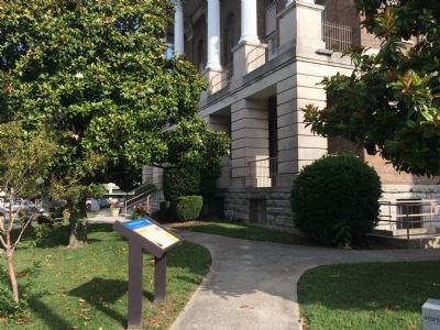
Location. 35° 28.969′ N, 86° 27.624′ W. Marker is in Shelbyville, Tennessee, in Bedford County. Marker is at the intersection of Public Square East (Tennessee Route 130) and West Depot Street, on the left when traveling north on Public Square East. The marker is on the southern ground of the Bedford County Courthouse. Touch for map. Marker is in this post office area: Shelbyville TN 37160, United States of America. Touch for directions.
Other nearby markers. At least 8 other markers are within walking distance of this marker. Tribute to World War I Veterans of Bedford County, Tennessee (here, next to this marker); Bedford County, Tennessee Veterans Memorial Plaza (within shouting distance of this marker); Tribute to Revolutionary War Veterans of Bedford County, Tennessee (within shouting distance of this marker); Masons Who Signed the Constitution of the U.S. (within shouting distance of this marker); In Memory of the "Shelbyville Rebels" Co. F. (within shouting distance of this marker); Tribute to Veterans of Bedford County, Tennessee (within shouting distance of this marker); Shelbyville, Tennessee (about 400 feet away, measured in a direct line); Tullahoma Campaign (about 500 feet away). Touch for a list and map of all markers in Shelbyville.
Credits. This page was last revised on June 16, 2016. It was originally submitted on July 18, 2015, by J. Makali Bruton of Accra, Ghana. This page has been viewed 1,818 times since then and 144 times this year. Photos: 1, 2. submitted on July 18, 2015, by J. Makali Bruton of Accra, Ghana. • Bernard Fisher was the editor who published this page.

