Kennesaw in Cobb County, Georgia — The American South (South Atlantic)
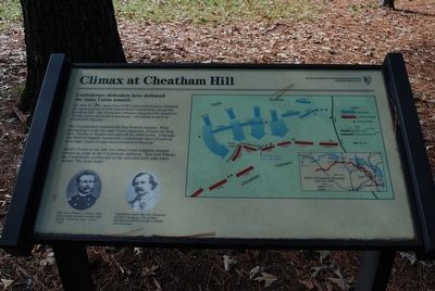
Climax at Cheatham Hill
Confederate defenders here defeated the main Union assault.
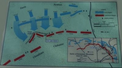
On June 27, 1864, more than 8,000 Union infantrymen attacked an equal number of well-entrenched Confederates along this low-lying hill. One Tennessee veteran compared the assault to “ocean waves driven by a hurricane…sweeping on as if by a irresistible impulse.”
The Confederates repulsed the first federal charge. While attempting to rally his eight Union regiments, 27 year old Brig. Gen. Charles G. Harker was shot off his white horse. Although one Federal brigade reached the Confederate lines ¼ mile to your right, Union troops soon retreated in disarray.
About ¼ mile to the left, two other Union brigades charged toward an angle in the Confederate defenses. This trail follows the Confederate earthworks in the area that both sides later named “The Dead Angle.”
Captions: Brig. Gen. Charles G. Harker, USA, fell mortally wounded nearby while yelling, “Come one, boys!” to his troops.
Confederates under Maj. Gen. Benjamin Franklin Cheatham, CSA, grimly defended the hill that would eventually bear his name.
Erected by Kennesaw Mountain National Battlefield Park, National Park Service.
Topics. This historical marker is listed in this topic list: War, US Civil. A significant historical date for this entry is June 27, 1864.
Location. 33° 56.181′ N, 84° 35.823′ W. Marker is in Kennesaw, Georgia, in Cobb County. Marker can be reached from Cheatam Hill Drive SW, 0.6 miles south of Dallas Road SW (Georgia Route 120), on the right when traveling south. Located in Kennesaw Mountain National Battlefield Park. Touch for map. Marker is in this post office area: Marietta GA 30064, United States of America. Touch for directions.
Other nearby markers. At least 8 other markers are within walking distance of this marker. Camouflaged Cannons (a few steps from this marker); Field Fortifications (within shouting distance of this marker); They Who Fell Here (within shouting distance of this marker); The Dead Angle (about 700 feet away, measured in a direct line); The Assault Falters (approx. 0.2 miles away); Illinois Monument (approx. 0.2 miles away); Monument to the Fallen (approx. 0.2 miles away); This Marks the Starting Point (approx. ¼ mile away). Touch for a list and map of all markers in Kennesaw.
Also see . . . Kennesaw Mountain National Battlefield Park. National Park Service (Submitted on August 19, 2015.)
Credits. This page was last revised on May 27, 2020. It was originally submitted on August 19, 2015, by Brandon Fletcher of Chattanooga, Tennessee. This page has been viewed 726 times since then and 27 times this year. Photos: 1, 2, 3. submitted on August 19, 2015, by Brandon Fletcher of Chattanooga, Tennessee. • Bernard Fisher was the editor who published this page.


