Chadron in Dawes County, Nebraska — The American Midwest (Upper Plains)
Paha Sapa
The heart of everything that is.
Inscription.
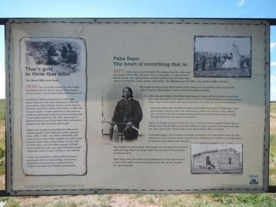
Paha Sapa is sacred land of the Lakota that the white man has named Black Hills. We never lived in this place. It is the womb of Mother Earth—the rightful home of birds and animals. We came here only for ceremonies, vision quests and burials. The lightning over the hills is the spirits of fallen warriors.
We fought bravely to keep white settlers from taking our sacred land. Their army built forts to protect their people as they traveled through our lands.
In 1868. the great Oglala Chief Red Cloud signed a treaty at Fort Laramie saying that Paha Sapa belonged to the Lakota. There would be no white settlers in our sacred land Their army would enforce the treaty and keep our lands free of white settlement.
But when Yellow Hair (General George Custer) discovered gold in Paha Sapa.,their government wanted to buy our land from us. When we refused, their soldiers left—and our land was no longer protected from thousands who came to seek fortune and claim our land for themselves.
Again. we fought to protect what was ours. Our great victory against Yellow Hair at Greasy Grass (Little Bighorn) led their soldiers to move onto the reservation and take our guns and horses. Many of the Great Sioux Nation fled to Canada.
Cold and hungry, most Lakota eventually returned to the reservations—but we still refused to sell or rent our lands. Now the U.S. Congress has created a new agreement to seize our land without our consent.
Our buffalo are almost gone. Our people are starving. Brave leaders such as Crazy Horse are dead. I fear that. the Great Sioux Nation is to be no more.
Paha Sapa, once the heart of everything that is, has also become a place that makes our hearts ache for the life we once shared as a proud people.
Side bar on the right
Thar’s gold in them that hills!
The Black Hills Gold Rush
1874: Two scientists attached to the Custer Expedition uncover gold in sacred Sioux land in South Dakota—and the Black Hills Gold Rush is on.
During the Allison Commission in l875.‘the Sioux refused to sell their reservation to the U.S. government. This territory. known as the Dakotas, had been assured to them in the Treaty of 1868. But the government. despite promises to the contrary, could not discourage prospectors from invading once word of gold leaked out. By 1876. thousands of fortune hunters were in the Black Hills and another round of war with the Sioux had begun.br Sidney was already an established trailhead for shipping goods to the Nebraska Indian agencies. From 1876 to 1881. the Sidney-Blackhills Trail carried much of the traffic. supplies and gold to and from the Black Hills mining towns. During l878 to 1879 alone. o moved along the trail—and some $200.000 in gold shipments moved south ‘to Sidney to the railroad.
Today. the trail offers a different kind of riches—panoramic views. unique geology. fascinating museums and attractions. national forests. outdoor recreation and friendly communities.
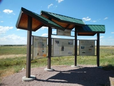
Erected by Nebraska Department of Road, Nebraska Byways Program and Federal Highway Administration.
Topics. This historical marker is listed in these topic lists: Exploration • Native Americans.
Location. Marker has been reported missing. It was located near 42° 50.088′ N, 103° 4.074′ W. Marker was in Chadron, Nebraska, in Dawes County. Marker was on Gold Rush Byway (U.S. 385) near Crazy Horse Memorial Highway (U.S. 20), on the left when traveling north. Touch for map. Marker was in this post office area: Chadron NE 69337, United States of America. Touch for directions.
Other nearby markers. At least 8 other markers are within 7 miles of this location, measured as the crow flies. The Fort Pierre-Fort Laramie Trail (within shouting distance of this marker); Fort Robinson - Camp Sheridan - Pine Ridge Indian Agency Road (approx. 2.9 miles away); Historic Northwestern Nebraska (approx. 2.9 miles away); The First Church in Chadron (approx.
3.4 miles away); The Chadron-Chicago Cowboy Race (approx. 3½ miles away); Chadron State College (approx. 3½ miles away); Bordeaux Trading Post (approx. 6.6 miles away); Chadron Creek Trading Post (approx. 6.7 miles away). Touch for a list and map of all markers in Chadron.
Regarding Paha Sapa. This marker is on U.S. Highway 385, just north of the intersection with U.S. Highway 20.
Also see . . . The Black Hills Story - Native Americas Online. Recently, satellites at the Eros Data Center, near Sioux Falls, South Dakota, photographed Paha Sapa from above. When the pictures were developed, scientists were shocked to learn that the Black Hills were the exact shape of the human heart. You could even see the chambers, veins, and arteries. (Submitted on October 6, 2015, by Barry Swackhamer of Brentwood, California.)
Credits. This page was last revised on May 27, 2021. It was originally submitted on October 6, 2015, by Barry Swackhamer of Brentwood, California. This page has been viewed 1,594 times since then and 345 times this year. Last updated on May 26, 2021, by Connor Olson of Kewaskum, Wisconsin. Photos: 1, 2, 3, 4. submitted on October 6, 2015, by Barry Swackhamer of Brentwood, California. • Devry Becker Jones was the editor who published this page.


