Charlotte in Rochester in Monroe County, New York — The American Northeast (Mid-Atlantic)
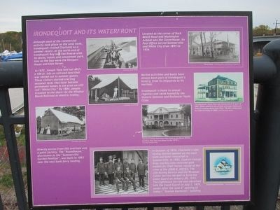
Irondequoit and its Waterfront
In 1872, Joseph Tone laid out 40 ft. x 100 ft. lots on railroad land that was rented out to summer guests. These visitors started erecting seasonal tents that later became permanent homes in the area we still call "Whie City." By 1884, people traveled to the shore via the Windsor Beach Railroad or electric trolley.
Directly across from this overlook was a paint factory. The "Roundhouse," also known as the "Summerville Garden Pavilion", was built in 1893 near the east bank ferry landing.
Located at the corner of Rock Beach Road and Washington Avenue was the Claverhouse. Its Post Office served Summerville and White City from 1895 to 1934.
Marine activities and boats have always been a part of Irondequoit's history, from its shipyards to its marinas.
Irondequoit is home to annual regattas and races hosted by the historic Genesee and Rochester Yacht Clubs.
The Rochester Yacht Club was incorporated in April of 1887. Shown above is one of their previous clubhouses. Today's building dates from 1922. The RYC celebrated its 125th birthday in 2002.
Yearly training exercises were held at the Naval Militia building that was torn down in the 1970's.
In October of 1876, Charlotte's Life-Saving Station opened on the west bank and later relocated to Summerville. In 1903, Captain George Gray and his crew received gold medals for their heroic rescue of the crew of the JOHN R. NOYES. The Life-Saving Service and the Revenue Cutter Service merged to form the Coast Guard on January 28, 1915. The Lighthouse Service was absorbed into the Coast Guard on July 1, 1939, weeks after the June 6th opening of today's "Station Rochester" building.
Topics. This historical marker is listed in these topic lists: Entertainment • Waterways & Vessels. A significant historical year for this entry is 1872.
Location. 43° 14.967′ N, 77° 36.712′ W. Marker is in Rochester, New York, in Monroe County. It is in Charlotte. Marker is at the intersection of Stutson Street and River Street, on the left when traveling east on Stutson Street. Touch for map. Marker is in this post office area: Rochester NY 14612, United States of America. Touch for directions.
Other nearby markers. At least 8 other markers are within walking distance of this marker. Stutson Street Bridge (here, next to this marker); Lighthouses (here, next to this marker); Port of the Genesee, New York (here, next to this marker); Resort Area (here, next to this marker); Champion of the Genesee River / A Beacon of Knowledge
(here, next to this marker); War of 1812 (here, next to this marker); The Village of Charlotte (a few steps from this marker); Boat Building (a few steps from this marker). Touch for a list and map of all markers in Rochester.
Regarding Irondequoit and its Waterfront. Marker is in the neighborhood of Charlotte in the City of Rochester.
Credits. This page was last revised on February 16, 2023. It was originally submitted on November 10, 2015, by Anton Schwarzmueller of Wilson, New York. This page has been viewed 609 times since then and 59 times this year. Photos: 1, 2, 3. submitted on November 10, 2015, by Anton Schwarzmueller of Wilson, New York.


