Cumberland Township near Gettysburg in Adams County, Pennsylvania — The American Northeast (Mid-Atlantic)
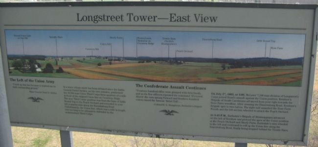
Longstreet Tower - East View
"I took up the line because it enabled me to hold commanding ground."
-Major General Daniel E. Sickles
In a move whose merit has been debated since the battle, General Sickles, on his own initiative, positioned the 10,500 man Union Third Corps three-quarters of a mile in front of the original Union line on Cemetery Ridge. The new Third Corps' position was from the base of Little Round Top to the Peach Orchard and extended to your left a quarter-mile along Emmittsburg Road. Unfortunately, the Union line, which was a mile in length, was too long to be adequately defended by the undermanned Third Corps.
The Confederate Assault Continues
"Fourteen hundred rifles were grasped with firm hands, and as the line officers repeated the command "Forward March" the men sprang forward and fourteen hundred voices raised the famous 'Rebel Yell'....
-Colonel B.G. Humphreys, Barksdale's Brigade
On July 2nd, 1863, at 5:00, McLaws' 7,100 man division of Longstreet's Corps joined Hood's assault against the Union position. Kershaw's Brigade of South Carolinians advanced from your right toward the Rose Farm woodline. After crossing the Emmittsburg Road, Kershaw's Brigade split in two halves. The right half assaulted the Rose Farm Woods and the left section wheeled to attack the Peach Orchard.
At 5:45 P.M., Barksdale's Brigade of Mississippians advanced on the left of Kershaw and pierced the apex of the Union position at the Peach Orchard and Sherfy Farm. Barksdale's men wheeled to the left and continued to roll up the Union line along the Emmittsburg Road, finally being stopped behind the Trostle Farm.
Topics. This historical marker is listed in this topic list: War, US Civil. A significant historical month for this entry is July 1972.
Location. 39° 47.996′ N, 77° 15.353′ W. Marker is near Gettysburg, Pennsylvania, in Adams County. It is in Cumberland Township. Marker is at the intersection of West Confederate Avenue and Millerstown Road, on the left when traveling south on West Confederate Avenue. Located at the viewing level of the Longstreet Tower, near stop six of the driving tour of Gettysburg National Military Park. Touch for map. Marker is in this post office area: Gettysburg PA 17325, United States of America. Touch for directions.
Other nearby markers. At least 8 other markers are within walking distance of this marker. Longstreet Tower - South View (here, next to this marker); The Ashland Virginia Artillery (a few steps from this marker); Freedom Threatened (a few steps from this marker); Lieut. General James Longstreet (within shouting distance of this marker); The Bedford Virginia Artillery (within shouting distance of this marker); McLaws's Division (within shouting distance of this marker); Carlton's Battery - Cabell's Battalion (about 300 feet away, measured in a direct line); Parker's Battery - Alexander's Battalion (about 300 feet away). Touch for a list and map of all markers in Gettysburg.
More about this marker. A panoramic photo on the marker points out the locations of Oak Hill, Spangler Barn, Cemetery Hill, Culp's Hill, Sherfy Farm, Trostle Barn, Peach Orchard, Little Round Top, and Rose Farm.
Credits. This page was last revised on February 7, 2023. It was originally submitted on August 8, 2008, by Craig Swain of Leesburg, Virginia. This page has been viewed 1,672 times since then and 27 times this year. Photos: 1, 2, 3. submitted on August 8, 2008, by Craig Swain of Leesburg, Virginia.


