East Aurora in Erie County, New York — The American Northeast (Mid-Atlantic)
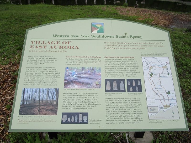
Village of East Aurora
Western New York Southtowns Scenic Byway
— Sinking Ponds Archeological Site —
Sinking Ponds is a Native American archeological site occupied repeatedly for thousands of years, containing Archaic, Transitional, Early Woodland and Late Woodland type artifacts.
Numerous stone tools, a carved steatite (soapstone) bowl, and some of the earliest fired-clay pottery known in the region have been recovered here. The site contains buried features like storage pits and hearths indicating where people lived. It was most likely inhabited as a spring-fall residence where conditions for fishing and birding in the shallow ponds and streams were ideal and diverse plant and animal resources were seasonally abundant.
View of Sinking Ponds in early spring with ice on pond.
Current and Previous Work at Sinking Ponds. The Sinking Ponds site was first recognized by archeologists in 1964 and was excavated in 1965 and 1966 by UB Anthropology students during a summer field school.
Field School students at Sinking Ponds site, summer 1964.
Researchers have conducted extensive work at the site, establishing some of what we know today about the Meadowood culture. The site was excavated again by UB students in 2011-2013 adding to our knowledge of the past. The Marian E. White Museum in the UB Anthropology Department has an extensive collection of artifacts and information from the site.
Pre-Meadowood type projectile points, c. 4,000-1000 B.C.
Significance of the Sinking Ponds Site. Sinking Ponds represents one of the most significant Meadowood type (c. 800-500B.C.) sites with profound implications for our region and the understanding of cultural developments throughout North America. Meadowood people are believed to be among the first to use many of the plant foods that would later become domesticated and grown as crops. Meadowood stone tools are among the most thin, finely shaped objects in the archeological record.
Meadowood type cache blades, c. 800-500 B.C.
Meadowood type projectile points, c. 800-500 B.C.
Numerous 'cache blades' or basic stone tool pre-forms were made at the site. These were used by Meadowood people to make finished tools like knives, spear points and drills. Cache blades were widely traded throughout the region, perhaps used as a form of currency. Made of local Onondaga chert or flint, similar tools are found in archeological sites all over the Northeastern US and Canada. The site contains the remains of a Meadowood house, where families may have lived for much of the year before moving to a winter residence.
With appreciation to
the University of Buffalo Department of Anthropology and others for their numerous contributions toward research at this site.
The Western New York Southtowns Scenic Byway is a 70 mile route encompassing five towns and three villages within southern Erie County, New York. For a listing of points of interest signs along the byway, go to www.wnyssb.org .
Erected by Western New York Southtowns Scenic Byway.
Topics. This historical marker is listed in this topic list: Anthropology & Archaeology. A significant historical year for this entry is 1964.
Location. 42° 46.726′ N, 78° 36.431′ W. Marker is in East Aurora, New York, in Erie County. Marker is on Pine Street, half a mile north of Porterville Road, on the right when traveling north. Marker is at the northern terminus of Pine Street - a dead end - and behind the derelict-looking East Aurora Water Works building. Touch for map. Marker is in this post office area: East Aurora NY 14052, United States of America. Touch for directions.
Other nearby markers. At least 8 other markers are within 2 miles of this marker, measured as the crow flies. East Aurora Cemetery (approx. 0.8 miles away); Elbert Hubbard / Michelangelo (approx. 0.9 miles away); The Roycroft Shops (approx. 0.9 miles away); Millard Fillmore House (approx. one mile away); Baker Memorial United Methodist Church (approx. 1.1 miles away); The Middle Road (approx. 1.1 miles away); Dedicated to Those Who Served (approx. 1.7 miles away); Republic F-84 (approx. 1.7 miles away). Touch for a list and map of all markers in East Aurora.
Also see . . . Western New York Southtowns Scenic Byway. (Submitted on June 7, 2017, by Anton Schwarzmueller of Wilson, New York.)
Credits. This page was last revised on June 7, 2017. It was originally submitted on June 7, 2017, by Anton Schwarzmueller of Wilson, New York. This page has been viewed 730 times since then and 101 times this year. Photos: 1, 2. submitted on June 7, 2017, by Anton Schwarzmueller of Wilson, New York.

