Near Emerson in Bartow County, Georgia — The American South (South Atlantic)
Railroad Block-house
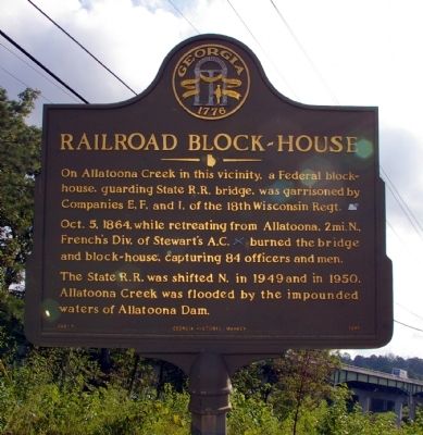
Photographed by David Seibert, August 13, 2009
1. Railroad Block-house Marker
Interstate 75 can be seen in the lower right corner
Oct. 5, 1864, while retreating from Allatoona, 2 mi. N., French’s Div. of Stewart’s A.C. [CS] burned the bridge and block-house, capturing 84 officers and men.
The State R.R. was shifted north in 1949 and in 1950, Allatoona Creek was flooded by the impounded waters of Allatoona Dam.
Erected 1952 by Georgia Department of Natural Resources. (Marker Number 008-7.)
Topics and series. This historical marker is listed in these topic lists: Railroads & Streetcars • War, US Civil. In addition, it is included in the Georgia Historical Society series list. A significant historical year for this entry is 1864.
Location. 34° 5.248′ N, 84° 42.858′ W. Marker is near Emerson, Georgia, in Bartow County. It is at the intersection of North Main Street SE (Georgia Route 293) and Sandtown Road SE, on the right when traveling west on North Main Street SE. The intersection is immediately south of where Sandtown Road passes under Interstate 75, just west of Lake Allatoona. Touch for map.
this page online

Regionally, this marker is in the Mountains. It is also in the American South and specifically in the Deep South. Globally, it is in North America, the Western Hemisphere, the Western World, and the Anglosphere. Historically, it finds itself in what was once the original Cherokee Nation, the territory of the Mississippian Culture, one of the original Thirteen Colonies, one of the Confederate States of America, and the Antebellum South.
Other nearby markers. At least 8 other markers are within 2 miles of this marker, measured as the crow flies: Battle of Allatoona (approx. 1½ miles away); Allatoona Pass (approx. 1.8 miles away); Wartime Allatoona (approx. 1.8 miles away); The Battle of Allatoona Pass (approx. 1.8 miles away); The Railroad (approx. 1.8 miles away); A Demand For Surrender (approx. 1.8 miles away); a different marker also named Battle of Allatoona (approx. 1.8 miles away); a different marker also named Allatoona Pass (approx. 1.8 miles away).
More about this marker. This marker replaced an earlier
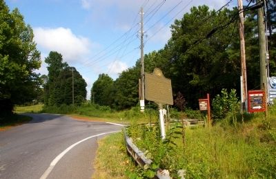
Photographed by David Seibert, August 13, 2009
2. Railroad Block-house Marker
Looking west on Georgia Highway 293, with Sandtown Road leading to the right (north) at the intersection
Credits. This page was last revised on July 6, 2017. It was originally submitted on August 16, 2009, by David Seibert of Sandy Springs, Georgia. This page has been viewed 2,446 times since then and 64 times this year. Last updated on July 5, 2017, by Thomas Dorman of Laurel, Maryland. Photos: 1, 2. submitted on August 16, 2009, by David Seibert of Sandy Springs, Georgia. • Bernard Fisher was the editor who published this page.
