Sanibel Island in Lee County, Florida — The American South (South Atlantic)
Sanibel & Everglades Restoration
The Caloosahatchee River Connection
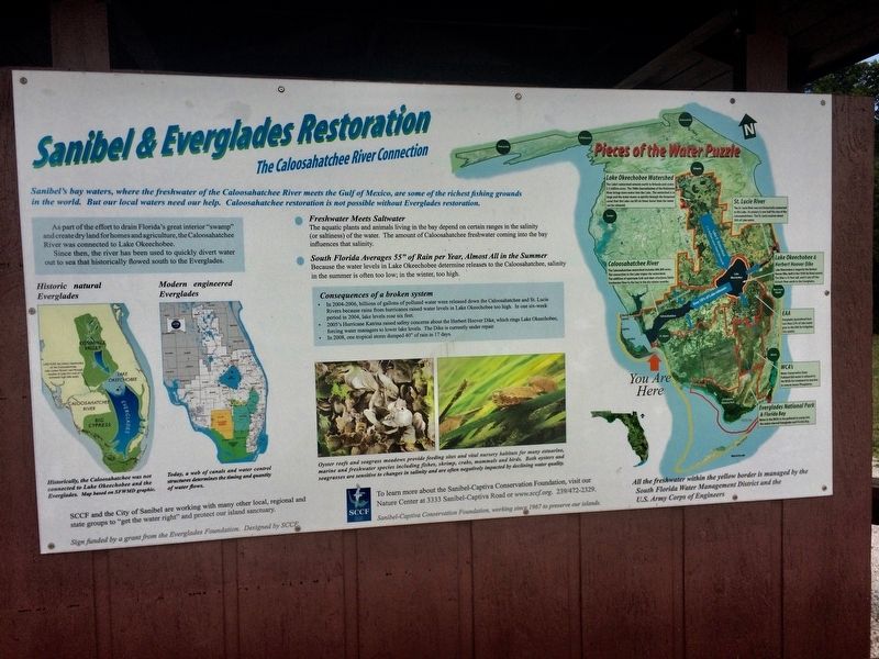
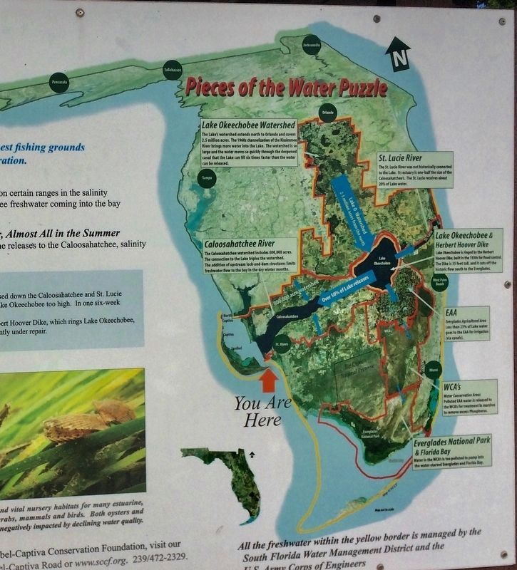
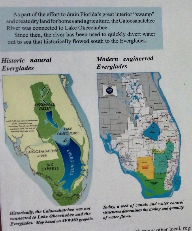
As part of the efforts to drain Florida’s great interior “swamp” and create dry lands for homes and agriculture, the Caloosahatchee River was connected to Lake Okeechobee. Since then, the river has been used to quickly divert water out to sea that historically flowed south to the Everglades
Historic natural Everglades
Historically, the Caloosahatchee was not connected to Lake Okeechobee and the Everglades. Map base on SFWMD graphic
Modern engineered Everglades
Today, a web of canals and water control structures determines the timing and quality of water flows.
SCCF and the City of Sanibel are working with many other local, regional and state groups to “get the water right” and protect our sanctuary.
Sign funded by a grant from the Everglades Foundation.
Designed by SCCF
• Freshwater Meets Saltwater
The aquatic plants and animals living in the bay depend on certain rages in the salinity (or saltiness) of the water. The amount of Caloosahatchee freshwater coming into the bay influences that salinity. • South Florida Averages 55” of Rain per Year, Almost All in the Summer
Because the water levels in Lake Okeechobee determines releases to the Caloosahatchee, salinity is the summer is often too low; in the winter too high.
Consequences of a broken system
• In 2004-2006, billions of gallons of polluted water were released down the Caloosahatchee and St. Lucie Rivers because rains from hurricanes raised water levels in Lake Okeechobb too high. In on six-week period in 2004, lake levels rose six feet.
• 2005's Hurricane Katrina raise safety concerns about the Herbert Hoover Dike, which rings Lake Okeechobee, forcing water managers to lower lake levels The Dike is currently under repair .
• 2008, one tropical storm dumped 40” of rain in 17 days.
Oyster reefs and seagrass meadows provide feeding sites and vital nursery habitats for many estuarine, marine and freshwater species including fishes, shrimp, crabs, mammals, and birds. Both oysters and seagrasses are sensitive to changes in salinity and are often negatively impacted by declining water quality.
To learn more about the Sanibel-Captiva Conservation Foundation, visit our Nature Center at 333 Sanibel-Captive Road or www.sccf.org 239/472/2329
Sanibel-Captive Conservation Foundation, working since 1967 to preserve our island.
Topics. This historical marker is listed in these topic lists: Animals • Environment. A significant historical year for this entry is 2004.
Location. 26° 27.165′ N, 82° 0.876′ W. Marker is on Sanibel Island, Florida, in Lee County. Marker is on Periwinkle Way. Marker is located Sanibel Lighthouse Beach Park. Touch for map. Marker is at or near this postal address: 110/153 Periwinkle Way, Sanibel FL 33957, United States of America. Touch for directions.
Other nearby markers. At least 8 other markers are within 6 miles of this marker, measured as the crow flies. Mollusks and the Environment (here, next to this marker); Molluscan Reproduction and Egg Case (here, next to this marker); Sea Turtles on Sanibel (a few steps from this marker); The Beach is a wild place (a few steps from this marker); Sanibel Lighthouse (within shouting distance of this marker); Nature's Landlord (within shouting distance of this marker); Plants and Progress (approx. 5.4 miles away); People and Plants (approx. 5.4 miles away). Touch for a list and map of all markers in Sanibel Island.
Credits. This page was last revised on August 30, 2017. It was originally submitted on July 29, 2017, by Sandra Hughes Tidwell of Killen, Alabama, USA. This page has been viewed 221 times since then and 14 times this year. Photos: 1, 2, 3. submitted on July 29, 2017, by Sandra Hughes Tidwell of Killen, Alabama, USA. • Bill Pfingsten was the editor who published this page.


