Near Remington in Fauquier County, Virginia — The American South (Mid-Atlantic)
Kelly’s Ford
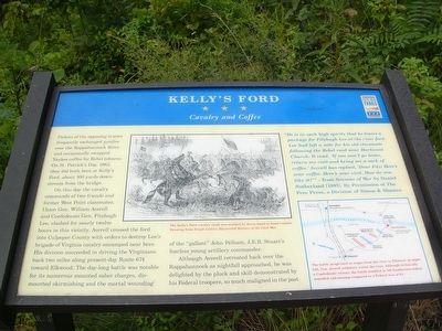
Cavalry and Coffee
On this day the cavalry commands of two friends and former West Point classmates, Union Gen. William Averell and Confederate Gen. Fitzhugh Lee, clashed for nearly twelve hours in this vicinity. Averell crossed the ford into Culpeper County with orders to destroy Lee’s brigade of Virginia cavalry encamped near here. His division succeeded in driving the Virginians back two miles along present-day Route 674 toward Elkwood. The day-long battle was notable for its numerous mounted saber charges, dismounted skirmishing and the mortal wounding of the “gallant” John Pelham, J.E.B. Stuart’s fearless young artillery commander.
Although Averell retreated back over the Rappahannock as nightfall approached, he was delighted by the pluck and skill demonstrated by his Federal troopers, so much maligned in the past.
“He is in such high spirits that he leaves a package for Fitzhugh Lee at the river ford. Lee had left a note for his old classmate following the Rebel raid near Hartwood Church. It read, ‘If you won’t go home, return my visit and bring me a sack of coffee.’ Averell has replied, “Dear Fitz: Here’s your coffee. Here’s your visit. How do you like it?’” —from Seasons of War by Daniel Sutherland [1995]. By Permission of The Free Press, a Division of Simon & Shuster.
(caption under large picture) The Kelly’s Ford cavalry clash was marked by fierce hand to hand combat. Drawing from Frank Leslie’s Illustrated History of the Civil War.
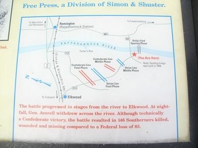
(caption under the map) The battle progressed in stages from the river to Elkwood. At nightfall, Gen. Averell withdrew across the river. Although technically a Confederate victory, the battle resulted in 146 Southerners killed, wounded and missing compared to a Federal loss of 85.
Erected by Virginia Civil War Trails.
Topics and series. This historical marker is listed in these topic lists: Bridges & Viaducts • War, US Civil. In addition, it is included in the Virginia Civil War Trails series list. A significant historical year for this entry is 1863.
Location. 38° 28.642′ N, 77° 46.954′ W. Marker is near Remington, Virginia, in Fauquier County. Marker is at the intersection of Kelly's Ford Road (Virginia Route 674) and Kelly's Ford Road (Virginia Route 620), on the right when traveling south on Kelly's Ford Road. Touch for map
. Marker is in this post office area: Remington VA 22734, United States of America. Touch for directions.
Other nearby markers. At least 8 other markers are within 4 miles of this marker, measured as the crow flies. The Battle of Brandy Station (here, next to this marker); The Battle of Kelly's Ford (here, next to this marker); a different marker also named Kelly's Ford (approx. ¼ mile away); a different marker also named Battle of Kelly’s Ford (approx. half a mile away); Major John Pelham, C.S.A. (approx. 0.9 miles away); "Chestnut Lawn" (approx. 1½ miles away); a different marker also named Battle of Kelly's Ford (approx. 3.1 miles away); a different marker also named Battle of Kelly's Ford (approx. 3.1 miles away). Touch for a list and map of all markers in Remington.
More about this marker. This marker, along with two others, was relocated to a spot on the south side of the river in 2011.
Credits. This page was last revised on July 23, 2018. It was originally submitted on August 31, 2007, by Kevin W. of Stafford, Virginia. This page has been viewed 4,413 times since then and 42 times this year. Last updated on September 18, 2017, by Samuel Paik of Gainesville, Virginia. Photos: 1, 2. submitted on August 31, 2007, by Kevin W. of Stafford, Virginia. 3. submitted on April 6, 2013, by Craig Swain of Leesburg, Virginia. 4. submitted on August 31, 2007, by Kevin W. of Stafford, Virginia. 5, 6. submitted on November 11, 2007, by Craig Swain of Leesburg, Virginia. • Bill Pfingsten was the editor who published this page.
