Littlestown in Adams County, Pennsylvania — The American Northeast (Mid-Atlantic)
Littlestown
20th Century
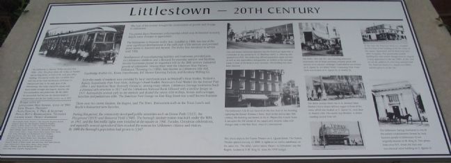
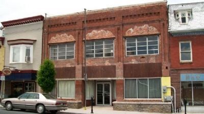
The photos depict businesses and properties which may be familiar to many despite some changes in appearance.
The Littlestown to Hanover trolley line, installed in 1908, was one of the most significant developments in the early part of the century and provided direct access to Hanover and beyond. The trolley line remained in service until 1932.
Development of manufacturing facilities and businesses provided jobs for Litlestown residents and a demand for everyday services and facilities. Several business played an important role in the 20th century industrial growth of Littlestown. Among them were the Littonian Shoe Factory, Littlestown Throwing Co. (1904), later known as Littlestown Silk Mill, Cambridge Rubber Co., Koons Greenhouses, B.F. Shriver Canning Factory, and Keystone Milling Co.
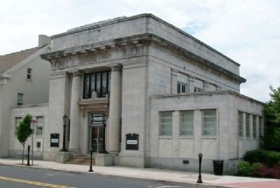
Everyday needs of residents were provided by local merchants such as Orndorff's Meat Market, Weikert's Bakery, Community Pure Food Store, Hollinger's Food Market, Bowman's Food Market (in the former Post Office) and American Store (formerly Crouse's), among many others. Littlestown Savings Institution built a classic style structure in 1917 and the Littlestown National Bank followed with a similar design in 1921. Automobiles arrived early in the century and shared the streets with trolleys, horses and carriages, bicyclists and pedestrians alike. The Basehoar Ford Garage on East King Street was a well known business.
There were two movie theaters, the Regent, and the Town. Restaurants such as the Texas Lunch and Boydie's Restaurant were favorites.
During this period, the community developed public amenities such as Crouse Park (1913), the Playground (1919) and Memorial Field (1948). The borough sanitary system was built under the WPA in 1941, and the first traffic lights were installed at the square in 1946. Parades, Christmas celebrations, and especially annual agricultural fairs marked the seasons for Littlestown citizens and visitors. By 2000 the Borough's population had grown to 3,947.
Topics and series. This historical marker is listed in these topic lists: Industry & Commerce • Railroads & Streetcars • Settlements & Settlers. In addition, it is included in the Works Progress Administration (WPA) projects series list. A significant historical year for this entry is 1908.
Location. 39° 44.68′ N, 77° 5.279′ W. Marker is in Littlestown, Pennsylvania, in Adams County. Marker is at the intersection of Queen Street (State Highway 97) and King Street (State Highway 194) when traveling north on Queen Street. Touch for map. Marker is in this post office area: Littlestown PA 17340, United States of America. Touch for directions.
Other nearby markers. At least
8 other markers are within walking distance of this marker. A different marker also named Littlestown (here, next to this marker); Peter (Klein) Little (here, next to this marker); Littlestown 250 Years (here, next to this marker); a different marker also named Littlestown (here, next to this marker); a different marker also named Littlestown (here, next to this marker); a different marker also named Littlestown (a few steps from this marker); Littlestown War Memorial (within shouting distance of this marker); Army of the Potomac (about 300 feet away, measured in a direct line). Touch for a list and map of all markers in Littlestown.
More about this marker. Several photographs illustrate the 20th Century changes to Littlestown. On the left is a photo showing The Littlestown to Hanover Trolley operated from 1908-1932. This photo shows the trolley car headed east on King Street, in front of the early post office building. The electric trolley lines (of which there were two at the time) ran between Littlestown to Hanover and York. In the early years of the 20th Century, the trolley shared the streets with horse-drawn carriages and wagons, bicycles, the first automobiles and pedestrians. By the 1940's the automobile had become the desired mode of transportation and the last trolley service ran in 1932.
Seven photos on the right side of the marker show additional scenes of the 20th Century:
This well-known Littlestown business was the first(?) car dealership in Littlestown. It was owned by D.D. Basehoar and C.L. Mehring and opened circa 1910. The dealership offered automotive repair services as well as new automobiles and gasoline, as evident in the early gas pump in front of the brick 2-story structure. The building has since been removed.
The 1930's, 40's and 50's saw a bustling downtown Littlestown, full of shops providing everyday goods and services to its citizens. Hollinger's Food Market was located on S. Queen St. at Lumber Street. Community Pure Food Store was located on S. Queen St. at Charles St.
At this time, the American Stores, Co. occupied the first floor of the building on the SE corner of the square. Apartments and the Red Cross were other occupants. This prominently located building has seen several changes from its original 2-story appearance in the late 1700's. In this view we see the addition of a 3rd story mansard roof. The American Stores Co. closed circa 1960's and this plaza is on the site.
The Littlestown 5 & 10 was located on the first floor in the building replacing the former Trimmer's Store. Built in the mid-to late 19th century, the building was known as the E. Meyers Dry Goods Store. It occupies the SW corner of the square
and remains today with changes only to the first floor, since it's construction.
The above picture shows the H.E. Orndorf Meat Market's horse drwn delivery wagon in front of the store, which was located on S. Queen St., next door to Hunter's Inn. The owner, Loy Orndorf, is shown standing second from left.
The Littlestown Savings Institution is one of the earliest establishments formed by local business people in Littlestown. It was originally located on W. King St. This photo, from circa 1917, shows the then new neo-classical stone building on S. Queen St.
This photo depicts the Towne Theater on S. Queen Street. The Towne Theater opened January 13, 1949. It replaced an earlier warehouse on the same site. The other, earlier movie theater in Littlestown was the Regent, located at 11 W. King St. (now the VFW Lodge).
Also see . . . A History of Littlestown. Article from the Littlestown Area Historical Society. (Submitted on August 30, 2008, by Craig Swain of Leesburg, Virginia.)
Credits. This page was last revised on January 21, 2020. It was originally submitted on August 30, 2008, by Craig Swain of Leesburg, Virginia. This page has been viewed 1,622 times since then and 58 times this year. Photos: 1. submitted on August 30, 2008, by Craig Swain of Leesburg, Virginia. 2. submitted on August 29, 2008, by Craig Swain of Leesburg, Virginia. 3, 4. submitted on January 13, 2019, by David Lassman of Waldorf, Maryland. 5, 6. submitted on September 4, 2010, by William Fischer, Jr. of Scranton, Pennsylvania.
