Near Tendoy in Lemhi County, Idaho — The American West (Mountains)
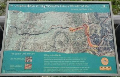
"Immence Ranges of High Mountains Still to the West of Us…"
- Meriwether Lewis, August 12, 1805
Photographed by Barry Swackhamer, June 24, 2017
1. "Immence Ranges of High Mountains Still to the West of Us..." Marker
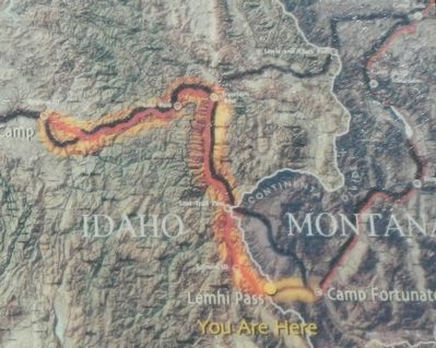
Caption: (legend) The Lewis and Clark Trail: RED - 1805 westward route; BLUE - 1806 eastward route; YELLOW - highlights the portage across the Rocky Mountains.
The modern map above is just a small slice of the United States along the Lewis and Clark Trail. Imagine trying to find you way across this land without such a map. Lewis and Clark, and many others who follow after them, have filled in the blanks for us.
Erected by Beaverhead-Deerlodge & Salmon-Chaillis National Forest.
Topics and series. This historical marker is listed in these topic lists: Exploration • Natural Features. In addition, it is included in the Lewis & Clark Expedition series list. A significant historical date for this entry is August 12, 1805.
Location. 44° 58.876′ N, 113° 26.771′ W. Marker is near Tendoy, Idaho, in Lemhi County. It can be reached from the intersection of
this page online

Regionally, this marker is in Central Idaho — Sawtooth Range. It is also in the American Mountain West and in the Lewis & Clark Corridor. Globally, it is in North America, the Rocky Mountains, the Western Hemisphere, the Western World, and the Anglosphere.
Other nearby markers. At least 8 other markers are within walking distance of this marker: A Communication Across the Continent by Water (a few steps from this marker); Agency Creek (approx. 0.2 miles away); Lemhi Pass (approx. 0.2 miles away); From Route ... To Road (approx. 0.4 miles away); Crossing the Great Divide (approx. 0.4 miles away); "Most Distant Fountain" of the Mighty Missouri (approx. ¾ mile away in Montana); The Beginning of the "Endless Missouri" (approx. ¾ mile away in Montana); Sacajawea Memorial Area (approx. ¾ mile away). Touch for a list and map of all markers in Tendoy.
More about this marker. This marker is located on the Continental Divide Trail.
This
Photographed by Barry Swackhamer, June 24, 2017
2. "Immence Ranges of High Mountains Still to the West of Us..." Marker, detail
Caption: (legend) The Lewis and Clark Trail: RED - 1805 westward route; BLUE - 1806 eastward route; YELLOW - highlights the portage across the Rocky Mountains.
Additional commentary.
1. Spelling of Immance on the marker
The spelling of Immence is taken verbatim from the marker, presumably verbatim from Meriwether Lewis' account of the trip.
— Submitted June 30, 2020, by Devry Becker Jones of Washington, District of Columbia.

Photographed by Barry Swackhamer, June 24, 2017
3. "Immence Ranges of High Mountains Still to the West of Us..." Marker
This marker is on the right, toward the background. DIRTY CAMERA LENS :(
Credits. This page was last revised on February 22, 2026. It was originally submitted on November 2, 2017, by Barry Swackhamer of Brentwood, California. This page has been viewed 554 times since then and 29 times this year. Photos: 1, 2, 3. submitted on November 2, 2017, by Barry Swackhamer of Brentwood, California.
