Marker Logo
THE HISTORICAL
MARKER DATABASE
“Bite-Size Bits of Local, National, and Global History”
Near Gainesville in Alachua County, Florida — The American South (South Atlantic)
 

Kanapaha Presbyterian Church

 
 
Kanapaha Presbyterian Church Marker image. Click for full size.
Photographed by Tim Fillmon, April 21, 2017
1. Kanapaha Presbyterian Church Marker
Inscription. In 1857, a group of Sea Island cotton planters from South Carolina who settled near here called an organizational meeting to establish Kanapaha Presbyterian Church. The Reverend William J. McCormick (1821-1883) was recruited from South Carolina to be its first pastor. The first sanctuary was erected in 1859 on land donated by Moses Ramsey on the old military road now known as S.W. 63rd Boulevard. In April 1859, McCormick conducted the first servives and the church was formally organized. During the Civil War, Kanapaha Church fell into disrepair. A new sanctuary designed in the Gothic Revival Style was built in 1886 near the train depot in South Arrendondo, later called Kanapaha. Beginning in 1961, services were held in a building closer to Gainesville but the congregation returned to the church here in 1970, after restoration was completed. Kanapaha Presbyterian Church is one of the oldest churches in Alachua County, and still retains the original pews, kerosene chandelier, stained glass windows, and bell. The churches original steeple, badly damaged by hurricanes in the 1940s, was restored in 2001.
 
Erected 2012 by
Paid Advertisement
Click or scan to see
this page online
Kanapaha Presbyterian Church and the Florida Department of State. (Marker Number F-735.)
 
Topics. This historical marker is listed in these topic lists: ArchitectureReligion & Religious Structures. A significant historical year for this entry is 1857.
 
Location. 29° 35.79′ N, 82° 25.378′ W. Marker is near Gainesville, Florida, in Alachua County. It is on Southwest 75th Terrace 0.1 miles south of Archer Road (State Road 24), on the left when traveling south. Touch for map. Marker is at or near this postal address: 6221 Southwest 75th Terrace, Gainesville FL 32608, United States of America. Touch for directions.

Regionally, this marker is in North Florida. It is also in the American South. Globally, it is in the North Atlantic Region, North America, a Gulf of Mexico state, the Western Hemisphere, the Western World, and the Anglosphere. Historically, it finds itself in what was once New Spain, the territory of the Mississippian Culture, one of the Confederate States of America, and the Antebellum South.

Other nearby markers. At least 8 other markers are within 2 miles of this marker, measured as the crow flies: Historic Haile Homestead At Kanapaha Plantation
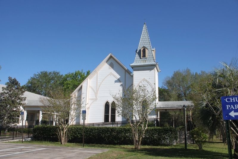
Kanapaha Presbyterian Church image. Click for full size.
Photographed by Tim Fillmon, April 21, 2017
2. Kanapaha Presbyterian Church
(approx. 0.7 miles away); Korean War (approx. 1.3 miles away); Oklahoma City Disaster (approx. 1.4 miles away); American Revolution (approx. 1.4 miles away); War of 1812 (approx. 1.4 miles away); Mexican-American War (approx. 1.4 miles away); War Between the States (approx. 1.4 miles away); Spanish-American War (approx. 1.4 miles away). Touch for a list and map of all markers in Gainesville.
 
 
Credits. This page was last revised on December 6, 2017. It was originally submitted on December 4, 2017, by Tim Fillmon of Webster, Florida. This page has been viewed 547 times since then and 50 times this year. Photos:   1, 2. submitted on December 4, 2017, by Tim Fillmon of Webster, Florida. • Bernard Fisher was the editor who published this page.

m=111045

CeraNet Cloud Computing sponsors the Historical Marker Database.
This website earns income from purchases you make after using our links to Amazon.com. We appreciate your support.
Paid Advertisement
Aug. 25, 2026