Near Ione in Morrow County, Oregon — The American West (Northwest)
Willow Creek Campground
Photographed by Barry Swackhamer, July 1, 2017
1. Willow Creek Campground Marker
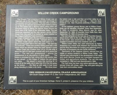
Oregon emigrant John Murray camped at Willow Creek September 16, 1853, and wrote: "camped about a mile up Willow Creek above where the road came to it ... good running water here & first rate grass." The next day he continued: "There was another trading post half a mile below where we camped where the water stands in pools -- Willow Creek has a bottom from 1/4 to 1/2 mile wide & about the half of it has even covered with rye & some fine grass -- The rest with greasewood -- among the greasewood is an abundance of alkali again. ... The bottom is enclosed by high rolling hills & the country
this page online
Of the eighteen graves Murray saw at Willow Creek, three can be identified. Elizabeth Toney died September 9, 1852, in childbirth; Mary Moore, age 34, died September 12, 1852, of mountain fever; Katie Rice, died September 13, 1852, of mountain fever.
The next campsite on the trail was at Fourmile Canyon, about seven miles to the west. The Cecil Store, 3/4 mile to the south, was constructed in 1862 and provided supplies to travelers and area residents until 1974.
Willow Creek Valley was used extensively by Native Americans as a travel route between the Columbia River and the Blue Mountains for hunting and gathering prior to the entry of Europeans into the Pacific Northwest.
Photographed by Barry Swackhamer, July 1, 2017
2. Willow Creek Campground Marker
Remnants of the Heppner Branch railroad line are visible at various locations in Willow Creek Valley. The railroad was instrumental in the development of the valley and south Morrow County as it provided transport for timber and agricultural products. The rail line was completed in 1888 and was discontinued in 1994.
The Cecil area has been active agriculturally since pioneer times with sheep, cattle, hay, and grain being the main farm commodities raised.
Erected 2007 by Oregon California Trails Association.
Topics and series. This historical marker is listed in these topic lists: Roads & Vehicles • Settlements & Settlers. In addition, it is included in the Oregon Trail series list. A significant historical date for this entry is September 16, 1853.
Location. 45° 37.842′ N, 119° 57.144′ W. Marker is near Ione, Oregon, in Morrow County. It is on Oregon Route 74 near Cecil Lane, on the left when traveling south. Touch for map. Marker is in this post office area: Ione OR 97843, United States of America. Touch for directions.

Regionally, this marker is in Eastern Oregon. It is also in the American Mountain West and in the Lewis & Clark Corridor. Globally, it is in North America, on the Pacific Rim, in the Western Hemisphere, in the Western World, and in the Anglosphere.
Other nearby markers. At least 2 other markers are within 5 miles of this marker, measured as the crow flies: Rocks, Sand & Wind (approx. 4½ miles away); Fourmile Canyon (approx. 4½ miles away).
Credits. This page was last revised on December 14, 2024. It was originally submitted on December 27, 2017, by Barry Swackhamer of Brentwood, California. This page has been viewed 1,204 times since then and 100 times this year. Photos: 1, 2. submitted on December 27, 2017, by Barry Swackhamer of Brentwood, California.
