Lowell in Lane County, Oregon — The American West (Northwest)
Building a Bridge
Industrious Labor
Photographed by Douglass Halvorsen, October 21, 2012
1. Building a Bridge Marker
Inscription.
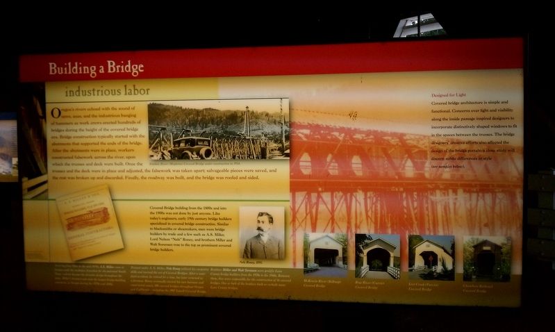
Building a Bridge. Industrious Labor. Oregon's rivers echoed with the sound of saws, axes, and the other industrious banging of hammers as work crews erected hundreds of bridges during the height of the covered bridge era. Bridge construction typically started with the abutments that supported the ends of the bridge. After the abutments were in place, workers constructed falsework across the river, upon which the trusses and deck were built. Once the trusses and the deck were in place and adjusted, the falsework was taken apart; salvageable pieces were saved, and the rest was broken up and discarded. Finally, the roadway was built, and the bridge was roofed and sided., Covered Bridge building from the 1800s and into the 1900s was not done by just anyone. Like today's engineers, early 19th century bridge builders specialized in covered bridge construction. Similar to blacksmiths or shoemakers, men were bridge builders by trade and a few such as A.S. Miller, Lord Nelson "Nels" Roney, and brother Miller and Walt Sorenson rose to the top as prominent covered bridge builders., Design for Light , Covered bridge architecture is simple and functional. Concerns over light and visibility along the inside passage inspired designers to incorporate distinctively shaped windows to fit in the spaces between the trusses. The bridge designers' creative efforts also affected the design of the bridge portals; a close study will discern subtle differences in style.
Oregon's rivers echoed with the sound of saws, axes, and the other industrious banging of hammers as work crews erected hundreds of bridges during the height of the covered bridge era. Bridge construction typically started with the abutments that supported the ends of the bridge. After the abutments were in place, workers constructed falsework across the river, upon which the trusses and deck were built. Once the trusses and the deck were in place and adjusted, the falsework was taken apart; salvageable pieces were saved, and the rest was broken up and discarded. Finally, the roadway was built, and the bridge was roofed and sided.
Covered Bridge building from the 1800s and into the 1900s was not done by just anyone. Like today's engineers, early 19th century bridge builders specialized in covered bridge construction. Similar to blacksmiths or shoemakers, men were bridge builders by trade and a few such as A.S. Miller, Lord Nelson "Nels" Roney, and brother Miller and Walt Sorenson rose to the top as prominent covered bridge builders.
Design for Light
Covered bridge architecture is simple and functional. Concerns over
Click or scan to see this page online
light and visibility along the inside passage inspired designers to incorporate distinctively shaped windows to fit in the spaces between the trusses. The bridge designers' creative efforts also affected the design of the bridge portals; a close study will discern subtle differences in style.
Topics and series. This historical marker is listed in this topic list: Bridges & Viaducts. In addition, it is included in the Covered Bridges series list.
Location. 43° 54.547′ N, 122° 46.769′ W. Marker is in Lowell, Oregon, in Lane County. It can be reached from S Pioneer St. Touch for map. Marker is in this post office area: Lowell OR 97452, United States of America. Touch for directions.
Regionally, this marker is in Oregon’s Willamette Valley. It is also on the American Pacific Coast, in the Pacific Northwest, and in the Lewis & Clark Corridor. Globally, it is in North America, in the Cascade Range, on the Ring of Fire, in the Pacific Rim, in the Western Hemisphere, in the Western World, and in the Anglosphere.
Other nearby markers. At least 8 other markers are within
Photographed by Douglass Halvorsen, October 21, 2012
Photographed by Douglass Halvorsen, October 21, 2012
3. Building a Bridge
Credits. This page was last revised on January 20, 2018. It was originally submitted on January 18, 2018, by Douglass Halvorsen of Klamath Falls, Oregon. This page has been viewed 344 times since then and 18 times this year. Photos:1, 2, 3. submitted on January 18, 2018, by Douglass Halvorsen of Klamath Falls, Oregon. • Bill Pfingsten was the editor who published this page.