Tahoe City in Placer County, California — The American West (Pacific Coastal)
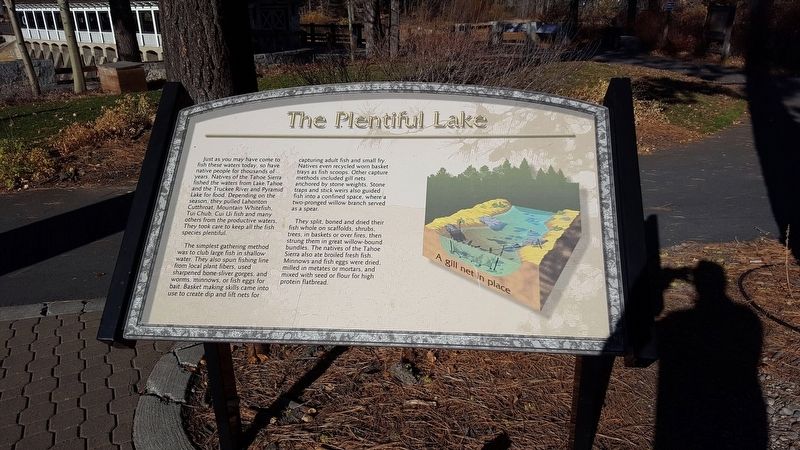
The Plentiful Lake
The simplest gathering method was to club large fish in shallow water. They also spun fishing line from local plant fibers, used sharpened bone-sliver gorges, and worms, minnows, or fish eggs for bait. Basket making skills came into use to create dip and lift nets for capturing adult fish and small fry. Natives even recycled worn basket trays as fish scoops. Other capture methods incuded gill nets anchored by stone weights. Stone traps and stick weirs also guided fish into a confined space, where a two-pronged willow branch served as a spear.
They split, boned and dried their fish whole on scaffolds, shrubs, trees, in baskets or over fires, then strung them in great willow-bound bundles. The natives of the Tahoe Sierra also ate broiled fresh fish. Minnows and fish eggs were dried, milled in metates or mortars, and mixed with seed or flour for high protein flatbread.
Erected by North Lake Tahoe Historical Society.
Topics. This historical marker is listed in these topic lists: Animals • Native Americans.
Location. 39° 9.997′ N, 120° 8.633′ W. Marker is in Tahoe City, California, in Placer County. Marker can be reached from West Lake Blvd north of Tahoe Tavern Road. Touch for map. Marker is at or near this postal address: 130 West Lake Blvd, Tahoe City CA 96145, United States of America. Touch for directions.
Other nearby markers. At least 8 other markers are within walking distance of this marker. A Tradition of Basketmaking (here, next to this marker); Lake Tahoe (here, next to this marker); The Gatekeeper’s Cabin and Museum (here, next to this marker); A Safe Harbor (a few steps from this marker); The Sacred Lake (a few steps from this marker); William B. Layton Park (within shouting distance of this marker); Conflict Over Water (within shouting distance of this marker); Lake Tahoe Outlet Works and Gatekeepers Cabin (within shouting distance of this marker). Touch for a list and map of all markers in Tahoe City.
More about this marker. Marker is located within the William B. Layton State Park.
Credits. This page was last revised on January 22, 2018. It was originally submitted on January 19, 2018, by Douglass Halvorsen of Klamath Falls, Oregon. This page has been viewed 166 times since then and 8 times this year. Photos: 1, 2. submitted on January 19, 2018, by Douglass Halvorsen of Klamath Falls, Oregon. • Andrew Ruppenstein was the editor who published this page.

