Coleville in Mono County, California — The American West (Pacific Coastal)
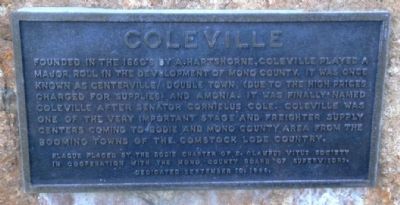
Coleville
Erected 1966 by the Bodie Chapter of the E. Clampus Vitus Society in cooperation with the Mono County Board of Supervisors (September 10, 1966).
Topics and series. This historical marker is listed in this topic list: Notable Places. In addition, it is included in the E Clampus Vitus series list. A significant historical year for this entry is 1860.
Location. 38° 34.14′ N, 119° 30.526′ W. Marker is in Coleville, California, in Mono County. Marker is on U.S. 395. Touch for map. Marker is at or near this postal address: 111527 Highway 395, Coleville CA 96107, United States of America. Touch for directions.
Other nearby markers. At least 8 other markers are within 15 miles of this marker, measured as the crow flies. Flag on Centennial Bluff (approx. 1.1 miles away); Topaz Post Office (approx. 2.4 miles away); The C-130 Crew (approx. 3.6 miles away); Golden Gate Mine (approx. 4 miles away); a different marker also named Golden Gate Mine (approx. 4 miles away); Pierce Station (approx. 14.7 miles away in Nevada); Wellington (approx. 14.7 miles away in Nevada); Hoye's Store (approx. 14.8 miles away in Nevada). Touch for a list and map of all markers in Coleville.
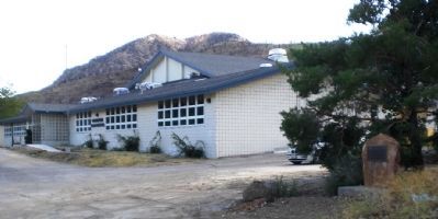
More about this marker. Marker is just north of Coleville High School.
Regarding Coleville. Senator Cole (for whom the town was named), was the leading organizer of the Republican Party in California in 1856. When he died in 1924 at the age of 102, he was the oldest former senator in US history.
Also see . . . Wikipedia Entry for Senator Cornelius Cole. (Submitted on September 10, 2008.)
Additional commentary.
1. Coleville
From Historic Legends of Mono County, written by Fred S. Cook and published by the California Traveler, Inc., Volcano, Ca. Publish date: unknown.
Coleville was named in honor of Cornelius Cole who was a Congressman from that area from 1863 to 1867 and then elected to the United States
Senate from 1867 to 1873. After serving one term in each house he seems to have dropped from political sight. The town was originally founded as Antelope Valley but at some time prior to 1880 they changed the name to honor this otherwise undistinguished senator. In 1882 the settlement showed a total of three business houses plus a hotel that doubled as the stage office. The valley seems to have been developed pretty much as a farming area and this, coupled with the fact that there was no extensive mining in the area may be responsible for the quietness of the valley.
One of the farmers who settled here in 1880 was a man named William J. Walker for whom the Walker River and Walker Lake were named, and indirectly the town of Walker that spring up at a much later date. This contradicts a one time popular theory that the river and lake came from the famed pioneer and mountain man, Joseph R. Walker. Maybe Joe did come this way at one time, but he passed through many valleys in his day and didn’t even bother to remember which ones, much less stop to name them.
At some time during the early days of this valley an idea arose to create an artificial lake, However not much was done about it until about 1920 when the course of the Walker river was changed. But there may have been a lake there before, whether artificial or man-made for in 1885 there was a town called Topaz located on the Kirman and Rickey Ranch. Here a mild argument develops. Was the town named after the lake, or the lake after the town? Those who argue the former state the lake was so named because of its clear blue waters, while those who reverse the christening are unable to state why the town was so called.
A part of the area is included in the Toiyabe National Forest, a name that derived from an Indian word meaning either “Black Mountain”, or “Big Mountain”. Even the Indians are not sure and a sage old chief says it might mean “Big, black mountain” for all he knows or cares.
Anyway, someone named the mountains the Toiyabes sometime before 1867 and the name carried on into the naming of the forest preserve that was created across the line in Nevada in 1908. However, the wise, wise men in Washington D.C. in their all seeing wisdom called the new forest “Toyabe”. This may have sounded fine in the nation’s capital but the local residents didn’t care too much for it. And so, in a day, when there was little more to fret about, they kicked up a head of steam and bureaucracy gave in and renamed it “Toiyabe”.
In 1946, a part of Mono National Forest was torn from its mother and welded with Nevada and so Toiyabe National Forest came to the Walker-Coleville area.
— Submitted May 18, 2010.
Credits. This page was last revised on June 16, 2016. It was originally submitted on September 10, 2008, by Andrew Ruppenstein of Lamorinda, California. This page has been viewed 2,570 times since then and 24 times this year. Photos: 1, 2. submitted on September 10, 2008, by Andrew Ruppenstein of Lamorinda, California. • Kevin W. was the editor who published this page.

