Darien in McIntosh County, Georgia — The American South (South Atlantic)
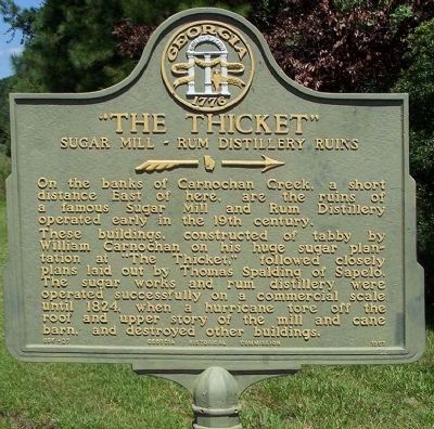
“The Thicket”
Sugar Mill - Rum Distillery Ruins
»—→
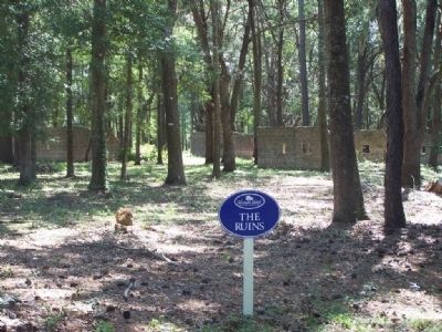
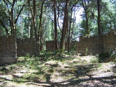
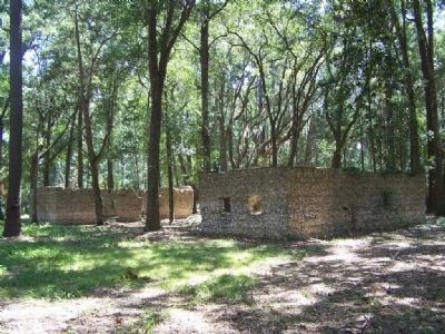
These buildings, constructed of tabby by William Carnochan on his huge sugar plantation at "The Thicket," followed closely plans laid out by Thomas Spalding of Sapelo. The sugar works and rum distillery were operated successfully on a commercial scale until 1824, when a hurricane tore off the roof and upper story of the mill and cane barn, and destroyed other buildings.
Erected 1957 by Georgia Historical Commission. (Marker Number 095-27.)
Topics and series. This historical marker is listed in these topic lists: Industry & Commerce • Landmarks • Notable Buildings. In addition, it is included in the Georgia Historical Society series list. A significant historical year for this entry is 1824.
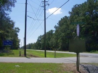
Location. 31° 25.87′ N, 81° 23.659′ W. Marker is in Darien, Georgia, in McIntosh County. Marker is at the intersection of Ridge Road (State Highway 99) and Tolomato Causeway (Mission Road) on Ridge Road. Touch for map. Marker is in this post office area: Darien GA 31305, United States of America. Touch for directions.
Other nearby markers. At least 8 other markers are within 5 miles of this marker, measured as the crow flies. Sapelo Island (approx. 2.4 miles away); Ardoch (approx. 3.6 miles away); Ashantilly (approx. 3.6 miles away); St. Andrew's Cemetery (approx. 3.8 miles away); Birthplace of John McIntosh Kell (approx. 4.4 miles away); Darien's Railroad and Depot (approx. 4.7 miles away); Columbus Square (approx. 4.7 miles away); The Savannah Lumber Company (approx. 4.8 miles away). Touch for a list and map of all markers in Darien.
Also see . . . NOAA, National Weather Service, Southern Region. Year:1824 Date(s): 14-15 September Principle Affected Area(s): Upper Georgia - major hurricane
Upper Georgia coastal waters - major hurricane
Lower Georgia - major Hurricane
Lower Georgia coastal waters - major hurricane
Northeast Florida - hurricane
Northeast Florida coastal waters - major hurricane
Landfall Point(s): Near Darien and St. Simons Island; The eye moved directly over the town of Darien, Ga. Remarks: Center probably skirted north of Caribbean islands and along the outer Bahamas. Exceeded 1804 storm in flooding and damage. St. Simons Island completely overflowed. 83 persons killed on this island. (not listed in Georgia by Dunn and Miller and is only indicated as being “Along the Georgia coast” by Tannehill. Well documented by Ludlum. William Page had 245 acres under cultivation on St. Simons Island and it was reported that this hurricane did extensive damage to his holdings on that island. “...as the sea dashed around them with all...[its] fury...until it had leveled to the earth the hospital, storehouse...cotton and corn-house, with many out buildings, crushing their carriage, carts and wagons, drowning their cattle an[d] other stock and spreading wild confusion...”
Robert Durfee’s Journal and Recollections of Newport, Rhode Island, Freetown,Massachusetts, New York City & Long Island, Jamaica & Cuba, West Indies & Saint SimonsIsland, Georgia ca. 1785-1810. Edited by Virginia Steele Wood, 1990, NOTES, Page 101.
John Couper’s losses were estimated to be between 50 and 60 thousand dollars. Thomas Spaulding of Sapelo island reported, a wall of water six feet high sweeping across the island and losses of 40 to 50 thousand dollars. The lighthouse on the south end of Sapelo was destroyed, with the sea running from 6 to 8 feet inside the structure. The beacons on Wolfs Island were likewise destroyed. The keeper of the Wolf’s Island beacon reports the door “Stove in, the sea breaking from 10 to 12 feet, which destroyed the whole of the oil.” Sullivan, Buddy. Early Days on the Georgia Tidewater: the story of McIntosh County
and Sapelo, Page 127.
William Carnochan’s Sugar Mill and rum distillery near Darien (at the Thicket) was destroyed and never rebuilt. “The islands on the coast were all under water. On the mainland at Carnochan’s flat, where Mr. [Richard L.] Morris and Mr. [T.P.] Pease now reside, at the Hudson place, and at Colonel Harrison’s (a continuation of the same flat ground) the tide rose over ten feet above the surface.” Ibid, Page 210.
The eye passed directly over the town of Darien, “The wind was first from the north and east. It blew with the greatest violence between eleven and twelve o’clock at night, after which it suddenly ceased. For half an hour it was nearly calm. Then it shifted to the west, and for some hours it blew more fiercely than ever. Under this change of direction the water fell rapidly, and many captives in trees and homes were permitted to come down and out.” Ibid., Page 156.
The Savannah Georgian, of 25 September 1824, reported, “The storm at Darien, and its neighborhood. Exceed that of 1804, both in violence and destruction.” This is confirmed by reports from the Darien Gazette over the next two weeks. The beaches of Cumberland Island, near the St Johns bar and at St Augustine were covered with wreckage.
Summary: Storm Tide values support major status and based on the storm’s track from
the Bahamas to Darien, will list as a major hurricane for Upper Georgia, Lower Georgia, and all of the coastal waters and as a hurricane along the northeast Florida coast. (Submitted on September 12, 2008, by Mike Stroud of Bluffton, South Carolina.)
Credits. This page was last revised on June 16, 2016. It was originally submitted on September 12, 2008, by Mike Stroud of Bluffton, South Carolina. This page has been viewed 1,902 times since then and 55 times this year. Photos: 1. submitted on April 4, 2011, by Mike Stroud of Bluffton, South Carolina. 2, 3, 4, 5, 6. submitted on September 12, 2008, by Mike Stroud of Bluffton, South Carolina. • Kevin W. was the editor who published this page.
