Near Omaha in Stewart County, Georgia — The American South (South Atlantic)
Indian Trail
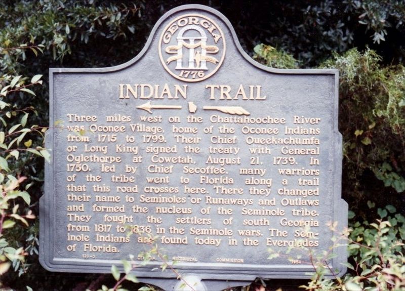
Photographed by Tim Fillmon, circa 1993
1. Indian Trail Marker
Erected by the Georgia Historical Commission. (Marker Number 128-3.)
Topics and series. This historical marker is listed in these topic lists: Indigenous Peoples and Communities • Settlements & Settlers. In addition, it is included in the Georgia Historical Society series list. A significant historical date for this entry is August 21, 1739.
Location. 32° 8.313′ N, 84° 58.201′ W. Marker is near Omaha, Georgia, in Stewart County. It is on Georgia Route 39 at milepost 15, 0.9 miles east of Holtzclaw Road, on the left when traveling east. Touch for map.
this page online

Regionally, this marker is on the Coastal Plain. It is also in the American South and specifically in the Deep South. Globally, it is in North America, the Western Hemisphere, the Western World, and the Anglosphere. Historically, it finds itself in what was once the territory of the Mississippian Culture, one of the original Thirteen Colonies, one of the Confederate States of America, and the Antebellum South.
Other nearby markers. At least 8 other markers are within 9 miles of this marker, measured as the crow flies: Fort McCreary – 1836 (approx. 2.6 miles away); Battle of Shepherd’s Plantation (approx. 4.6 miles away); Florence (approx. 5½ miles away); Providence United Methodist Church (approx. 5.8 miles away); Spanish Fort, 1689-1691 (approx. 6.1 miles away in Alabama); Rev. David Walker Lowe (approx. 6.2 miles away); Fort Jones (approx. 6.7 miles away); Antioch Institute (approx. 8.9 miles away). Touch for a list and map of all markers in Omaha.
Another marker is no longer nearby. Roanoke (was approx. 7.3 miles away but has been confirmed missing).
More about this marker. Source of marker text: Georgia Historical Society.
Related marker. Click here for another marker that is related to this marker.
Also see . . . Treaty of Coweta Town (1739). Proceedings of the Assembled Estates of all the Lower Creek Nation on Saturday the Eleventh day of August Anno Domini 1739. (Submitted on May 3, 2018, by Mark Hilton of Montgomery, Alabama.)
Credits. This page was last revised on October 8, 2020. It was originally submitted on May 3, 2018, by Mark Hilton of Montgomery, Alabama. This page has been viewed 956 times since then and 60 times this year. Photo 1. submitted on October 7, 2020, by Tim Fillmon of Webster, Florida.
Editor’s want-list for this marker. Photo of marker and a wide shot of the marker and its surroundings. • • Can you help?
