Jasper in Marion County, Tennessee — The American South (East South Central)
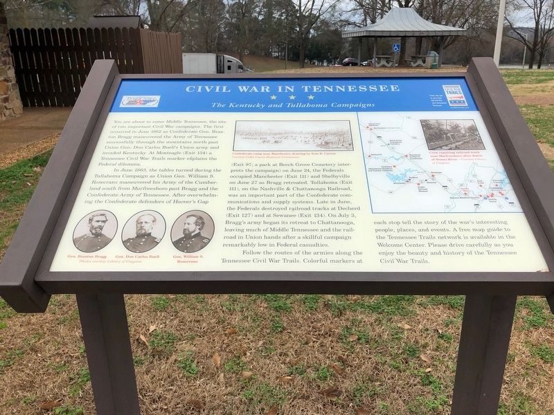
Civil War in Tennessee
The Kentucky and Tullahoma Campaigns
In June 1863, the tables turned during the Tullahoma Campaign as Union Gen. William S. Rosecrans maneuvered his Army of Cumberland south from Murfreesboro past Bragg and the Confederate Army of Tennessee. After overwhelming the Confederate defenders of Hoover's Gap (Exit 97; a park at Beech Grove Cemetery interprets the campaign) on June 24, the Federals occupied Manchester (Exit 111) and Shelbyville on June 27 as Bragg retreated. Tullahoma (Exit 111), on the Nashville & Chattanooga Railroad, was an important part of the Confederate communications and supply systems. Late in June, the Federals destroyed railroad tracks to Decherd (Exit 127) and at Sewanee (Exit 134). On July 3, Bragg's army began its retreat to Chattanooga, leaving much of Middle Tennessee and the railroad in Union hands after a skillful campaign remarkably low in Federal casualties.
Follow the routes of the armies along the Tennessee Civil War Trails. Colorful markers at each stop tell the story of the war's interesting people, places, and events. A free map guide to the Tennessee Trails network is available in the Welcome Center. Please drive carefully as you enjoy the beauty and history of the Tennessee Civil War Trails.
Erected by Tennessee Civil War Trails.
Topics and series. This historical marker is listed in this topic list: War, US Civil. In addition, it is included in the Tennessee Civil War Trails series list. A significant historical month for this entry is June 1863.
Location. 35° 1.595′ N, 85° 33.454′ W. Marker is in Jasper, Tennessee, in Marion County. Marker is on Interstate 24W at milepost 160,, 1.2 miles west of Shellmound Road (Tennessee Route 156), on the right when traveling west. Located at the Nickajack/Marion County Tennessee Welcome Center. Touch for map. Marker is in this post office area: Jasper TN 37347, United States of America. Touch for directions.
Other nearby markers. At least 8 other markers are within 5 miles of this marker, measured as the crow flies. Federal-Georgia Road (approx. 1.2 miles away); Location and Capacity (approx. 1.8 miles away); Hales Bar Dam (approx. 1.8 miles away); Running Water Creek Bridge (approx. 3.1 miles away); Love's Ferry (approx. 3.2 miles away); Ebenezer Cumberland Presbyterian Church (approx. 3.3 miles away); The TVA System of Multipurpose Dams
(approx. 4 miles away); Betsy Pack (approx. 5 miles away). Touch for a list and map of all markers in Jasper.
Credits. This page was last revised on May 28, 2018. It was originally submitted on May 26, 2018, by Sandra Hughes Tidwell of Killen, Alabama, USA. This page has been viewed 595 times since then and 44 times this year. Photos: 1, 2. submitted on May 26, 2018, by Sandra Hughes Tidwell of Killen, Alabama, USA. • Bernard Fisher was the editor who published this page.

