Lorman in Claiborne County, Mississippi — The American South (East South Central)
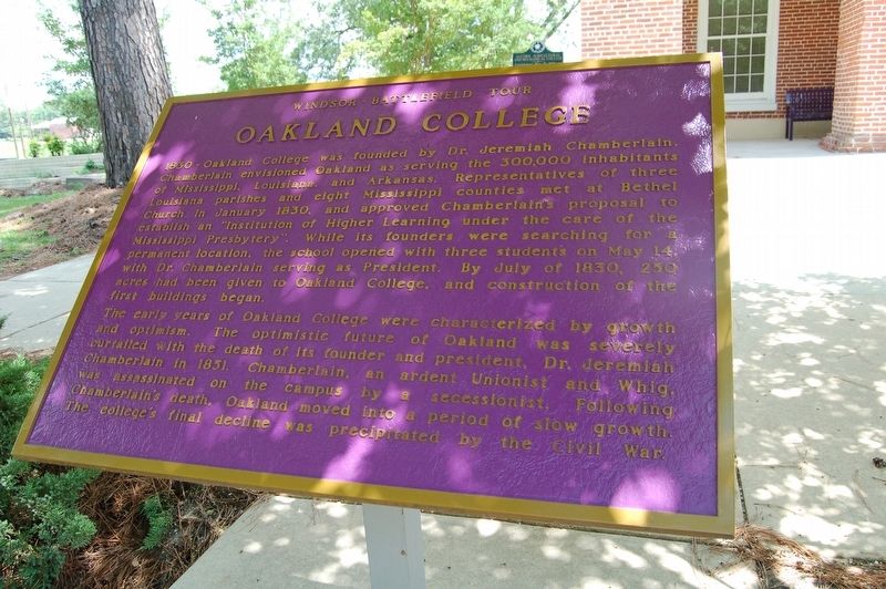
Oakland College
Windsor Battlefield Tour
1830 - Oakland College was founded by Dr. Jeremiah Chamberlain. Chamberlain envisioned Oakland as serving the 300,000 inhabitants of Mississippi. Louisiana, and Arkansas. Representatives of three Louisiana parishes and eight Mississippi counties met at Bethel Church in January 1830, and approved Chamberlain''s proposal to establish an "Institution of Higher Learning under the care of Mississippi Presbytery". While its founders were searching for a permanent location, the school opened with three students on May 14, with Dr Chanberlain serving as President. By July of 183O, 250 acres had been given to Oakland College, and construction of the first buildings began.
The early years of Oakland College were characterized by growth and optimism. The optimistic future of Oakland was severely curtailed with the death of its founder and president, Dr. Jeremiah Chamberlain in 1851.Chamberlain, an ardent Unionist and Whig was assassinated on the campus by a secessionist. Following Chamberlain's death, Oakland moved into a period of slow growth. The college's final decline was precipitated by the Civil War.
Topics. This historical marker is listed in these topic lists: Education • War, US Civil.
Location. 31° 52.567′ N, 91° 8.396′ W.
Other nearby markers. At least 8 other markers are within 2 miles of this marker, measured as the crow flies. The Chapel (here, next to this marker); Oakland Memorial Chapel (a few steps from this marker); Alcorn State University (1871) (a few steps from this marker); The Original Campus (a few steps from this marker); Alcorn Agricultural And Mechanical College (a few steps from this marker); Belles Lettres Building (approx. 0.2 miles away); Old Port Gibson to Rodney Road (approx. 0.3 miles away); Canemount Plantation (approx. 1.4 miles away). Touch for a list and map of all markers in Lorman.
Credits. This page was last revised on July 8, 2018. It was originally submitted on July 7, 2018, by Cajun Scrambler of Assumption, Louisiana. This page has been viewed 250 times since then and 25 times this year. Photos: 1, 2. submitted on July 7, 2018.

