Near Henrico in Henrico County, Virginia — The American South (Mid-Atlantic)
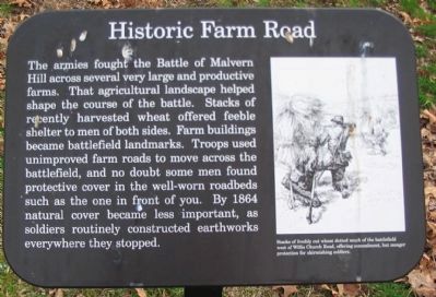
Historic Farm Road
Topics. This historical marker is listed in this topic list: War, US Civil. A significant historical year for this entry is 1864.
Location. 37° 25.072′ N, 77° 15.151′ W. Marker is near Henrico, Virginia, in Henrico County. Marker is at the intersection of Carters Mill Road and Willis Church Road (Virginia Highway 156), on the right when traveling south on Carters Mill Road. Located in the Malvern Hill Battlefield Unit of the Richmond National Battlefield Park. Touch for map. Marker is in this post office area: Henrico VA 23231, United States of America. Touch for directions.
Other nearby markers. At least 8 other markers are within walking distance of this marker. The Confederate High Water Mark (within shouting distance of this marker); Confederate Futility (about 600 feet away, measured in a direct line); Outgunned (approx. 0.2 miles away); a different marker also named Confederate Futility (approx. 0.2 miles away); "Madness" (approx. 0.2 miles away); Battlefield Burials (approx. 0.2 miles away); Malvern Hill (approx. 0.2 miles away); Seven Days Battles (approx. 0.2 miles away). Touch for a list and map of all markers in Henrico.
More about this marker. On the right is a drawing of soldiers fighting around wheat stacks. Stacks of freshly cut wheat dotted much of the battlefield west of Willis Church Road, offering concealment, but meager protection for skirmishing soldiers.

2. Malvern Hill - CWPT
Civil War Preservation Trust's efforts to preserve portions of the battlefield.
Click for more information.
Click for more information.
Credits. This page was last revised on July 7, 2021. It was originally submitted on April 2, 2010, by Craig Swain of Leesburg, Virginia. This page has been viewed 869 times since then and 17 times this year. Last updated on July 21, 2018, by Bradley Owen of Morgantown, West Virginia. Photos: 1. submitted on April 2, 2010, by Craig Swain of Leesburg, Virginia. 2. submitted on March 28, 2010, by Craig Swain of Leesburg, Virginia. 3, 4. submitted on April 2, 2010, by Craig Swain of Leesburg, Virginia. • Andrew Ruppenstein was the editor who published this page.


