Bethel Park in Allegheny County, Pennsylvania — The American Northeast (Mid-Atlantic)
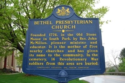
Bethel Presbyterian Church
American Presbyterian and Reformed Historical Site
Photographed by Mike Wintermantel, May 1, 2011
1. Bethel Presbyterian Church Marker
Erected 1951 by Pennsylvania Historical and Museum Commission. (Marker Number 58.)
Topics and series. This historical marker is listed in these topic lists: Religion & Religious Structures • War, US Revolutionary. In addition, it is included in the American Presbyterian and Reformed Historic Sites, and the Pennsylvania Historical and Museum Commission (PHMC) series lists. A significant historical year for this entry is 1776.
Location. 40° 20.186′ N, 80° 2.874′ W. Marker is in Bethel Park, Pennsylvania, in Allegheny County. It is on Bethel Church Road east of Marshall Road, on the right when traveling east. Touch for map. Marker is at or near this postal address: 2999 Bethel Church Road, Bethel Park PA 15102, United States of America. Touch for directions.

Regionally, this marker is in Greater Pittsburgh. It is also in the American Northeast, in the
this page online
Other nearby markers. At least 8 other markers are within 3 miles of this marker, measured as the crow flies: Peter S. Edwards, Jr. (approx. 1.1 miles away); Schoolhouse Arts Center (approx. 1.1 miles away); Fulton Log House (approx. 1.2 miles away); Upper St. Clair Veterans Park (approx. 1.2 miles away); In Honor of All American Veterans (approx. 2.4 miles away); Second Division (approx. 2.4 miles away); Private (First Class) Edmund M. Wilson (approx. 2.4 miles away); The Ladies of the Grand Army of the Republic (approx. 2.4 miles away). Touch for a list and map of all markers in Bethel Park.
Regarding Bethel Presbyterian Church. Bethel Presbyterian Church is one of 445 American Presbyterian and Reformed Historical Sites registered between 1973 and 2003 by the Presbyterian Historical Society
Photographed by Mike Wintermantel, May 1, 2011
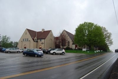
2. Bethel Presbyterian Church Marker
The following text is taken from the Presbyterian Historical Society website:
Rev. John McMillan, D.D., a missionary in Western Pennsylvania, noted in his diary on November 5, 1776, "Tuesday preached at Peter's Creek, baptized five children." This date is the first recorded date of a preaching service in what is now Bethel Presbyterian Church. Originally known as the Peter's Creek congregation, the congregation eventually divided into two, the Eastern Division and the Western Division. Sometime between October 18, 1785 and April 18, 1786, the name of the Eastern Division was changed to Lebanon and the name of the Western Division was changed to Bethel. Bethel Presbyterian Church was officially incorporated on March 11, 1907. The current building was erected and dedicated in May 1910.
Credits. This page was last revised on September 6, 2018. It was originally submitted on May 1, 2011, by Mike Wintermantel of Pittsburgh, Pennsylvania. This page has been viewed 1,825 times since then and 94 times this year. Last updated on August 23, 2018, by Douglass Halvorsen of Klamath Falls, Oregon. Photos: 1, 2. submitted on May 1, 2011, by Mike Wintermantel of Pittsburgh, Pennsylvania. • Bill Pfingsten was the editor who published this page.
