East Liberty in Pittsburgh in Allegheny County, Pennsylvania — The American Northeast (Mid-Atlantic)
East Liberty Presbyterian Church
Historic Landmark
| — | American Presbyterian and Reformed Historical Site | — |
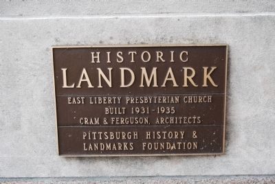
Photographed by Mike Wintermantel, May 4, 2013
1. East Liberty Presbyterian Church Marker
Built 1931-1935
Cram & Ferguson, Architects
Erected by Pittsburgh History and Landmarks Foundation. (Marker Number 363.)
Topics and series. This historical marker is listed in this topic list: Religion & Religious Structures. In addition, it is included in the American Presbyterian and Reformed Historic Sites, and the Pennsylvania, Pittsburgh History and Landmarks Foundation series lists.
Location. 40° 27.682′ N, 79° 55.528′ W. Marker is in Pittsburgh, Pennsylvania, in Allegheny County. It is in East Liberty. It can be reached from the intersection of Penn Avenue and Penn Avenue, on the right when traveling east. Located in Pittsburgh's East Liberty section. Touch for map. Marker is at or near this postal address: 116 South Highland Avenue, Pittsburgh PA 15206, United States of America. Touch for directions.

Regionally, this marker is in the American Northeast, in the Mid-Atlantic, in the Ohio River Valley, in Appalachia, and specifically in Northern Appalachia. Globally, it is in North America, the Western Hemisphere, the
this page online
Other nearby markers. At least 8 other markers are within walking distance of this marker: A different marker also named East Liberty Presbyterian Church (about 700 feet away, measured in a direct line); Motor Square Garden (about 700 feet away); Portal of Industry (approx. 0.2 miles away); Suburban Catalyst (approx. 0.2 miles away); St. Peter's Evangelical and Reformed Church (approx. ¼ mile away); 1st Drive-In Filling Station (approx. 0.3 miles away); Alder Court Apartments (approx. 0.3 miles away); Peabody Memorial to Soldiers (approx. 0.4 miles away). Touch for a list and map of all markers in Pittsburgh.
Regarding East Liberty Presbyterian Church. East Liberty Presbyterian Church is one of 445 American Presbyterian and Reformed Historical Sites registered between 1973 and 2003 by the Presbyterian Historical Society (PHS), headquartered in Philadelphia. Approved sites received a metal plaque featuring John Calvin’s seal and
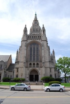
Photographed by Mike Wintermantel, May 4, 2013
2. East Liberty Presbyterian Church Marker
The following text is taken from the Presbyterian Historical Society website:
The land for East Liberty Presbyterian Church was donated in 1819, and the congregation was formally organized as the First Presbyterian Church of East Liberty in 1828. The current sanctuary, a massive gothic building with stained glass windows, opened in 1935. It occupies a full city block, and it has 100 rooms, a 202-foot nave, and an Aeolian-Skinner organ with 7,734 pipes. The church’s architect, Ralph Adams Cram, also designed Princeton’s University Chapel. The building was a gift from Mr. and Mrs. Richard Beatty Mellon to serve as a monument to Presbyterianism in Western Pennsylvania. In May 1958, the church hosted the final General Assembly meeting for the PCUSA before it joined with the United Presbyterian Church of North America.
Also see . . . East Liberty Presbyterian Church. (Submitted on May 6, 2013, by Mike Wintermantel of Pittsburgh, Pennsylvania.)
Credits. This page was last revised on February 2, 2023. It was originally submitted on May 6, 2013, by Mike Wintermantel of Pittsburgh, Pennsylvania. This page has been viewed 840 times since then and 53 times this year. Last updated on August 23, 2018, by Douglass Halvorsen of Klamath Falls, Oregon. Photos: 1, 2. submitted on May 6, 2013, by Mike Wintermantel of Pittsburgh, Pennsylvania. • Bill Pfingsten was the editor who published this page.
