Weston & Danforth's architecture
Play detective along the Byway. Discover clues to the past in
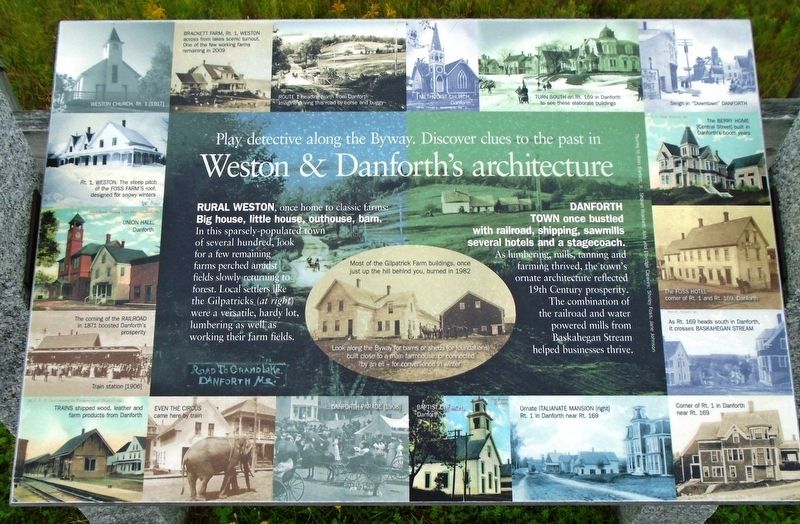
Rural Weston, once home to classic farms: Big house, little house, outhouse, barn.
In this sparsely-populated town of several hundred, look for a few remaining farms perched amidst fields slowly returning to forest. Local settlers like the Gilpatricks ([photo] at right) were a versatile, hardy lot, lumbering as well as working their farm fields.
[center inset photo caption reads]
Most of the Gilpatrick Farm buildings, once just up the hill behind you, burned in 1982
Look along the Byway for barns or sheds (or foundations) built close to a main farmhouse, or connected by an ell - for convenience in winter
Danforth Town once bustled with railroad, shipping, sawmills[,] several hotels and a stagecoach.
As lumbering, mills, tanning and farming thrived, the town's ornate architecture reflected 19th Century prosperity. The combination of the railroad and water powered mills from Baskahegan Stream helped businesses thrive.
[Border photos, clockwise from top left, read]
• Weston Church, Rt. 1 (1917)
• Brackett Farm, Rt. 1, Weston across from lakes scenic turnout. One of the few working farms remaining in 2009
• Route
this page online
• Methodist Church, Danforth
• Turn south on Rt. 169 in Danforth to see these elaborate buildings
• Sleigh in "Downtown" Danforth
• The Berry Home [Central Street] built in Danforth's boom years
• The Foss Hotel corner of Rt. 1 and Rt. 169, Danforth
• As Rt. 169 heads south in Danforth, it crosses Baskahegan Stream
• Corner of Rt. 1 in Danforth near Rt. 169
• Ornate Italianate mansion [right] Rt. 1 in Danforth near Rt. 169
• Baptist Church, Danforth
• Danforth Parade [1908]
• Even the Circus came here by train
• Trains shipped wood, leather and farm products from Danforth
• The coming of the Railroad in 1871 boosted Danforth's prosperity - Train station [1906]
• Union Hall, Danforth
• Rt. 1, Weston. The steep pitch of the Foss Farm's roof, designed for snowy winters
Erected by Million Dollar View Scenic Byway.
Topics. This historical marker is listed in these topic lists: Agriculture • Horticulture & Forestry • Industry & Commerce • Settlements & Settlers. A significant historical year for this entry is 1982.
Location. 45° 41.582′ N,


Regionally, this marker is in Downeast Maine. It is also in the American Northeast, in New England, and on the Eastern Seaboard. Globally, it is in the North Atlantic Region, North America, the Great North Woods, the Western Hemisphere, the Western World, and the Anglosphere. Historically, it finds itself in what was once the Viceroyalty of New France and also Acadia.
Other nearby markers. At least 8 other markers are within 9 miles of this marker, measured as the crow flies: Welcome to Million Dollar View Scenic Byway (here, next to this marker); The "sleeping giant" view of Mount Katahdin (a few steps from this marker); Rivers & Streams: Ancient Highways of the Wabanaki (within shouting distance of this marker); Town of Weston Honor Roll (approx. 2.9 miles away); When trees were used for tanning (approx. 3.1 miles away); A rich fishing tradition continues year-round (approx. 3.1 miles away); Chiputneticook Chain of Lakes (approx. 3.1 miles away); Orient Veterans Memorial (approx. 8½ miles away). Touch for a list and map of all markers in Weston.
Also see . . . Million Dollar View Scenic Byway. (Submitted on October 21, 2018, by William Fischer, Jr. of Reynoldsburg, Ohio.)
Credits. This page was last revised on October 22, 2018. It was originally submitted on October 21, 2018, by William Fischer, Jr. of Reynoldsburg, Ohio. This page has been viewed 346 times since then and 24 times this year. Photos: 1, 2. submitted on October 21, 2018, by William Fischer, Jr. of Reynoldsburg, Ohio.
