Stevensville in Queen Anne's County, Maryland — The American Northeast (Mid-Atlantic)
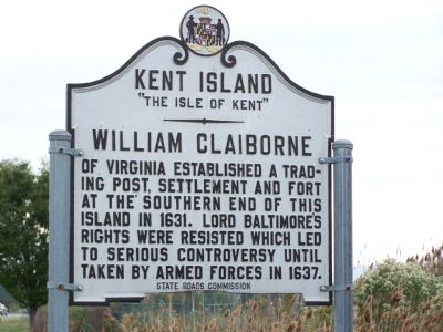
Kent Island
“The Isle of Kent”
Erected by State Roads Commission.
Topics. This historical marker is listed in these topic lists: Colonial Era • Forts and Castles • Industry & Commerce • Settlements & Settlers. A significant historical year for this entry is 1631.
Location. 38° 58.57′ N, 76° 19.38′ W. Marker is in Stevensville, Maryland, in Queen Anne's County. Marker is at the intersection of Maryland Route 8 and Marina Club Road, on the right when traveling south on State Route 8. Touch for map. Marker is in this post office area: Stevensville MD 21666, United States of America. Touch for directions.
Other nearby markers. At least 8 other markers are within walking distance of this marker. British Takeover (approx. 0.4 miles away); Broad Creek Cemetery (approx. 0.4 miles away); Christ Church (approx. 0.4 miles away); Stevensville Train Depot (approx. 0.6 miles away); Grollman's Store (approx. 0.6 miles away); a different marker also named Christ Church (approx. 0.6 miles away); Cray House (approx. 0.6 miles away); Country Store (approx. 0.6 miles away). Touch for a list and map of all markers in Stevensville.
Credits. This page was last revised on November 10, 2020. It was originally submitted on October 24, 2007, by Bill Pfingsten of Bel Air, Maryland. This page has been viewed 2,073 times since then and 64 times this year. Last updated on January 26, 2019, by Carl Gordon Moore Jr. of North East, Maryland. Photos: 1. submitted on October 24, 2007, by Bill Pfingsten of Bel Air, Maryland. 2. submitted on October 25, 2020, by Allen C. Browne of Silver Spring, Maryland. • Andrew Ruppenstein was the editor who published this page.

