Jacksontown in Licking County, Ohio — The American Midwest (Great Lakes)
Licking Township Fallen Firemen
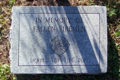
Photographed by William Fischer, Jr., October 19, 2008
1. Licking Township Fallen Firemen Marker
Erected by Licking Township Fire Department.
Topics. This historical marker is listed in these topic lists: Charity & Public Work • Heroes.
Location. 39° 58.144′ N, 82° 24.751′ W. Marker is in Jacksontown, Ohio, in Licking County. It can be reached from Jacksontown Road (Ohio Route 13) 0.1 miles north of Ridgely Tract Road ( Route 308). Marker is in Jacksontown Cemetery, off Jacksontown Road. Touch for map. Marker is in this post office area: Jacksontown OH 43030, United States of America. Touch for directions.

Regionally, this marker is in the Columbus Metropolitan Area. It is also in the American Midwest, in the Corn Belt, in Appalachia, and specifically in Northern Appalachia. Globally, it is in North America, the Western Hemisphere, the Western World, and the Anglosphere. Historically, it finds itself in what was once the Haudenosaunee (Iroquois) Confederacy, the territory of the Mississippian Culture, and the Northwest Territory.
Other nearby markers. At least 8 other markers are within 3 miles of this marker, measured
this page online

Photographed by William Fischer, Jr., October 19, 2008
2. Licking Township Fallen Firemen Marker

Photographed by William Fischer, Jr., October 19, 2008
3. Jacksontown Cemetery Sign on Ohio Route 13
Credits. This page was last revised on June 16, 2016. It was originally submitted on October 24, 2008, by William Fischer, Jr. of Reynoldsburg, Ohio. This page has been viewed 1,034 times since then and 13 times this year. Photos: 1, 2. submitted on October 24, 2008, by William Fischer, Jr. of Reynoldsburg, Ohio. 3. submitted on October 30, 2008, by William Fischer, Jr. of Reynoldsburg, Ohio. • Kevin W. was the editor who published this page.
