American University Park in Northwest Washington in Washington, District of Columbia — The American Northeast (Mid-Atlantic)
On the Circle
Top of the Town
| — | Tenleytown Heritage Trail | — |
Photographed by J. J. Prats, March 19, 2011
1. On the Circle Marker
Click on the image to examine it closely.
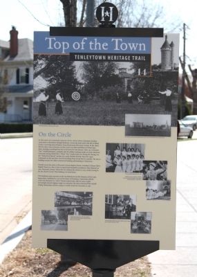
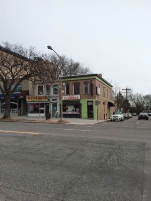
In the 1930s city engineers created Tenley Circle where commuters heading cross-town or downtown changed streetcars. Across the street and to the left of Tenley Circle, a surviving strip of historic Grant Road meets Wisconsin Avenue. In the 1890s, the two-story, stucco structure on that corner was John and Rebecca O’Day’s feed store, stocking everything from hay to kerosene for area farmers. After 1915 it became “Doc” Scholl’s pharmacy, a popular spot for soldiers training nearby at Camp American University during World War I. When “Doc” Gauley took over during the roaring ’20s, the “Tenleytown Special” sundae was a soda fountain favorite. Since the 1940s restaurants on this spot have served everything from corned beef to cannolis. The stucco building remains the oldest commercial building still standing in Tenleytown.
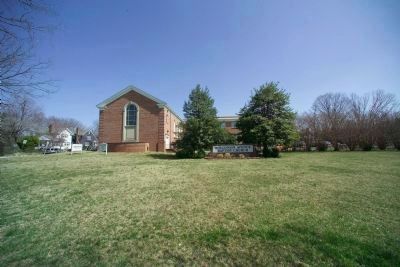
Directly across the circle is Wisconsin Avenue Baptist Church. Founded as Mount Tabor Baptist Church in 1880, it first occupied land donated by parishioner Mary Burrows at 4620 Wisconsin Avenue. When the city widened the avenue in 1924, nearly erasing its lot, the church moved. This building is its
this page online
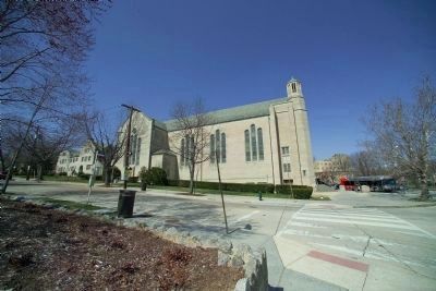
The handsome stone structure on the rise behind you was the Seminary of Our Lady Immaculate, established in 1905 by the Sisters of Providence. Immaculata offered a first-rate education to a “select” female student body. After 80 years, as girls increasingly rejected religious single-sex education, the sisters announced the school’s closing. Immaculata sold this campus to nearby American University in 1987.
Erected 2010 by Cultural Tourism DC. (Marker Number 14.)
Topics and series. This historical marker is listed in these topic lists: Railroads & Streetcars • Roads & Vehicles. In addition, it is included in the Tenleytown Heritage Trail series list. A significant historical year for this entry is 1915.
Location. 38° 56.765′ N, 77° 4.751′ W. Marker is in Northwest Washington in Washington, District of Columbia. It is in American University Park. It is at the intersection of Tenley Circle Northwest and Yuma Street Northwest, on the right when traveling south on Tenley Circle Northwest. Touch for map. Marker is in this post office area: Washington DC 20016, United States of America. Touch for directions.

Regionally,

Photographed by Devry Becker Jones (CC0), March 5, 2026
2. A sticker with a new paragraph has been placed over the third paragraph.
The sticker reads:
The handsome stone structure on the rise behind you was the Seminary of Our Lady Immaculate, established in 1905 by the Sisters of Providence. "Immaculata" offered a first-rate education to female students. After 80 years, the order announced the preparatory school's closing. A year later, despite protests by the school community, the order sold this campus to nearby American University.
Other nearby markers. At least 8 other markers are within walking distance of this marker: A Crossroads, Then and Today (about 400 feet away, measured in a direct line); Tennally's Town: My, How You've Grown (about 400 feet away); St. Ann's Parish Armed Forces Memorial (about 400 feet away); To the Rescue (about 400 feet away); The Rest (about 700 feet away); Community Building Blocks (about 700 feet away); Beer, Popcorn, and Penny Candy (about 800 feet away); A Country Road (approx. 0.2 miles away). Touch for a list and map of all markers in Northwest Washington.
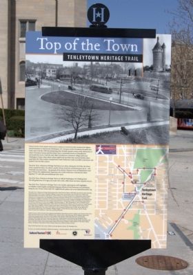
More about this marker. There are a number of photographs on the marker.
♦ Caption of large photograph above text on the reverse (common) side of marker, “A Wisconsin Ave. streetcar leaves the boarding platform at Tenley Circle, 1938. The building at the left with the billboard
Photographed by J. J. Prats, March 19, 2011
3. On the Circle Marker, Reverse
♦ Caption of large photograph above text, “Immaculata Seminary students practice archery.”
♦ Upper right inset, “The 1903 view shows Immaculata Seminary and St. Ann’s Church before Tenley Circle was built.”
♦ Starting below, counterclockwise, “The Immaculata basketball team, 1963.”
♦ “Despite two years of protests including the one at right, Immaculata closed, holding its final graduation in 1986, ♦ below.”
♦ “Young members of Wisconsin Avenue Baptist Church, above, and a Sunday School class, 1950s” ♦ to the right.
♦ “Inside Gauley’s Pharmacy, 1939.” above.” The building is visible at the right edge of this 1950s view of the Wisconsin Ave. streetcar” ♦ on the left.
Photographed by Tom Fuchs, March 19, 2011
4. Seminary of Our Lady Immaculate
Photographed by Tom Fuchs, March 19, 2011
5. Baptist Church
Photographed by J. Makali Bruton, January 25, 2015
6. "Two-story, stucco structure" at Wisconsin and Grant, today a laundry.
Photographed by J. Makali Bruton, January 25, 2015
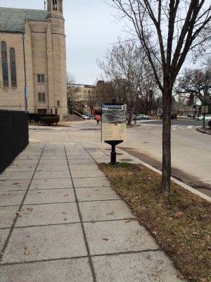
7. Wide view of the reverse of the On the Circle Marker
Credits. This page was last revised on March 5, 2026. It was originally submitted on October 1, 2011, by J. J. Prats of Powell, Ohio. This page has been viewed 1,325 times since then and 37 times this year. Last updated on March 8, 2019, by Devry Becker Jones of Washington, District of Columbia. Photos: 1. submitted on October 1, 2011, by J. J. Prats of Powell, Ohio. 2. submitted on March 5, 2026, by Devry Becker Jones of Washington, District of Columbia. 3. submitted on October 1, 2011, by J. J. Prats of Powell, Ohio. 4, 5. submitted on October 2, 2011, by Tom Fuchs of Greenbelt, Maryland. 6, 7. submitted on January 25, 2015, by J. Makali Bruton of Washington, District of Columbia. • Devry Becker Jones was the editor who published this page.
