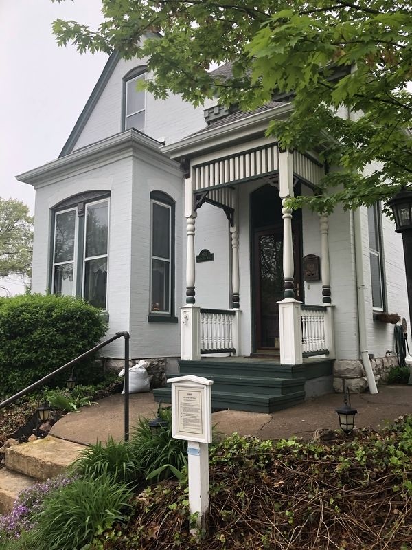
St. Charles in St. Charles County, Missouri — The American Midwest (Upper Plains)
1889
603 North Sixth Street
— of The Commons Neighborhood —
1834
John and Herman Wilke arrived from Hanover, Germany.
1850's
John and Herman established successful farms in Portage Des Sioux Township, now Orchard Farms.
1860's
John and Herman both served for the Union during the Civil War, John's rank is unknown; Herman's rank was Lieutenant in the Home Guard. Southern renegades raided Herman Wilke's farm to kill him. His assailant was shot by Henry Kettler, a hired hand. Kettler served as a private in the Civil War 1861-1862.
1867
John Wilke purchased half of this block along 6th Street.
1873
John Wilke purchased the rest of this block along 7th Street.
1889
John Wilke had this house built for his retirement.
It is a brick Queca Ann with a double brick dentils beneath the cornices. The steep hipped roof has two cross gables. The turned porch posts support a spindled frieze suspended from the porch roof. The bay windows with their concave mansard roofs are distinctive.
1902
In order to pay John Wilke's heirs, house and lot were sold to the highest bidder, Henry Kettler, the long time family friend and defender.
The house remained with Kettler and his heirs for almost 80 years.
Erected by Saint Charles Commons Neighborhood Association .
Topics. This historical marker is listed in these topic lists: Architecture • War, US Civil. A significant historical year for this entry is 1834.
Location. 38° 47.298′ N, 90° 29.156′ W. Marker is in St. Charles, Missouri, in St. Charles County. Marker is on North 6th Street north of Lewis Street, on the left when traveling north. Touch for map. Marker is at or near this postal address: 603 North 6th Street, Saint Charles MO 63301, United States of America. Touch for directions.
Other nearby markers. At least 8 other markers are within walking distance of this marker. Circa 1899 (a few steps from this marker); Circa 1940 (a few steps from this marker); 612 North Sixth Street (a few steps from this marker); Circa 1894 (about 400 feet away, measured in a direct line); Circa 1904 (about 400 feet away); 1900 (about 600 feet away); Circa 1939 (about 700 feet away); 1902 (about 700 feet away). Touch for a list and map of all markers in St. Charles.
Credits. This page was last revised on May 1, 2019. It was originally submitted on May 1, 2019, by Devry Becker Jones of Washington, District of Columbia. This page has been viewed 279 times since then and 26 times this year. Photos: 1, 2. submitted on May 1, 2019, by Devry Becker Jones of Washington, District of Columbia.

