
North Beach in Calvert County, Maryland — The American Northeast (Mid-Atlantic)
Early Businesses
Picturing the Past
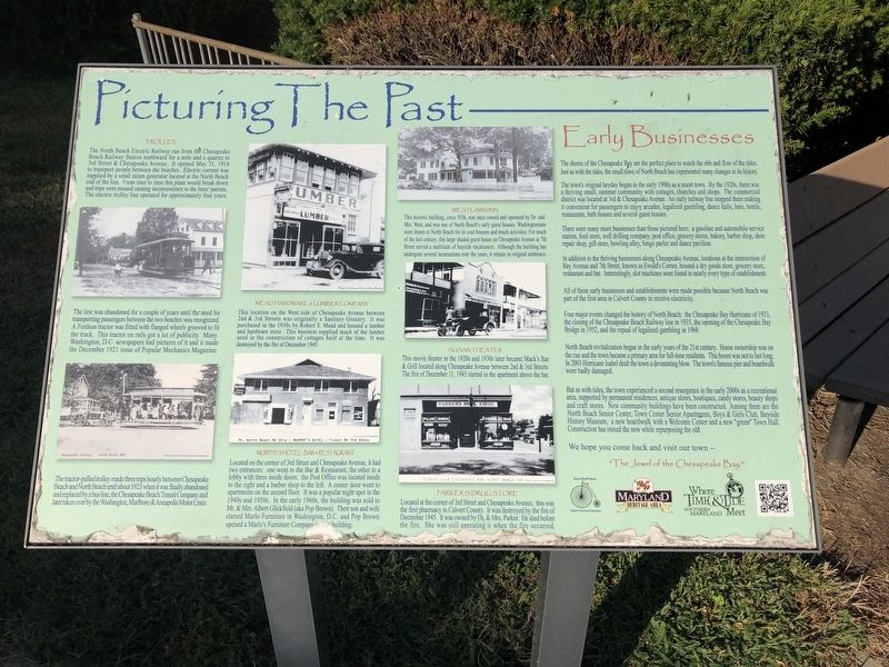
The shores of the Chesapeake Bay are the perfect place to watch the ebb and flow of the tides. Just as with the tides, the small town of North Beach has experimented many changes in its history.
The town's original heyday began in the early 1900s as a resort town. By the 1920s, there was a thriving small, summer community with cottages, churches and shops. The commercial district was located at 3rd & Chesapeake Avenue. An early railway line stopped there making it convenient for passengers to enjoy arcades, legalized gambling, dance halls, bars, hotels, restaurants, bath houses and several guest houses.
There were many more businesses than those pictured here: a gasoline and automobile service station, feed store, well drilling company, post office, grocery stores, bakery, barber shop, shoe repair shop, gift store, bowling alley, bingo parlor and dance pavilion.
In addition to the thriving businesses along Chesapeake Avenue, locations at the intersection of Bay Avenue and 7th Street, known as Ewald's Corner, housed a dry goods store, grocery store, restaurant and bar. Interestingly, slot machines were found in
this page online
All of these early businesses and establishments were made possible because North Beach was part of the first area in Calvert County to receive electricity.
Four major events changed the history of North Beach: the Chesapeake Bay Hurricane of 1933, the closing of the Chesapeake Beach Railway line in 1935, the opening of the Chesapeake Bay Bridge in 1952, and the repeal of legalized gambling in 1968.
North Beach revitalization began in the early years of the 21st century. Home ownership was on the rise and the town became a primary area for full-time residents. This boom was not to last long. In 2003 Hurricane Isabel dealt the town a devastating blow. The town's famous pier and boardwalk were badly damaged.
But as with tides, the town experienced a second resurgence in the early 2000s as a recreational area, supported by permanent residences, antique stores, boutiques, candy stores, beauty shops and craft stores. New community buildings have been constructed. Among them are the North Beach Senior Center, Town Center Senior Apartments, Boys & Girls Club, Bayside History Museum, a new boardwalk
We hope you come back and visit our town --
[Captions:]
The line was abandoned for a couple of years until the need for transporting passengers between the two beaches was recognized. A Fordson tractor was fitted with flanged wheels grooved to fit the track. This tractor on rails got a lot of publicity. Many Washington, D.C. newspapers had pictures of it and it made the December 1921 issue of Popular Mechanics Magazine.
The tractor-pulled trolley made three trips hourly between Chesapeake Beach and North Beach until about 1923 when it was finally abandoned and replaced by a bus line, the Chesapeake Beach Transit Company and later taken over by the Washington, Marlboro & Annapolis Motor Lines.
Erected by Town of North Beach Historic Preservation Commission, Maryland Heritage Area, Southern Maryland.
Topics. This historical marker is listed in these topic lists: Entertainment • Industry & Commerce • Railroads & Streetcars • Settlements & Settlers. A significant historical date for this entry is May 31, 1914.
Location. 38° 42.387′ N, 76° 32.055′ W. Marker is in North Beach, Maryland, in Calvert County. It is at the intersection of 4th Street and Dayton Avenue, on the left when traveling east on 4th Street. Touch for map. Marker is at or near this postal address: 4025 4th Street, North Beach MD 20714, United States of America. Touch for directions.

Regionally, this marker is in Southern Maryland. It is also in the American South, specifically in the Upper South, in the Mid-Atlantic, in the Tidewater, in the Chesapeake Bay Region, and on the Eastern Seaboard. Globally, it is in the North Atlantic Region, North America, the Western Hemisphere, the Western World, and the Anglosphere. Historically, it finds itself in what was once one of the original Thirteen Colonies and also the Antebellum South.
Other nearby markers. At least 8 other markers are within walking distance of this marker: Beach & Pier (approx. 0.2 miles away); Beach Buccaneers (approx. 0.2 miles away); Russell David Hall (approx. 0.2 miles away); North Beach Boardwalk (approx. 0.2 miles away); The Town of North Beach (approx. 0.2 miles away); Working Watermen (approx. 0.2 miles away); North Beach Pier (approx. 0.2 miles away); Lt Brendan Looney (approx. 0.2 miles away). Touch for a list and map of all markers in North Beach.
Credits. This page was last revised on April 14, 2021. It was originally submitted on August 30, 2019, by Devry Becker Jones of Washington, District of Columbia. This page has been viewed 1,567 times since then and 95 times this year. Photos: 1, 2. submitted on August 30, 2019, by Devry Becker Jones of Washington, District of Columbia.
