Residential Architecture
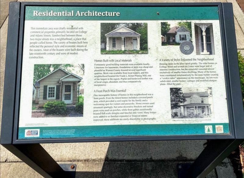
This immediate area was chiefly residential with commercial properties primarily located on College and Adams Streets. Sandwiched between those two major streets was a neighborhood, a place that people called home. The variety of houses built here reflected the personal style and economic means of the owners. Most of the houses were built during the late-nineteenth century and were of modest construction.
Homes Build with Local Materials
Fortunately good building materials were available locally. Limestone for basements, foundations or piers was cheap and plentiful as Warren County boasted several significant quarries. Brick was available from local makers, and this neighborhood boasted the Frank J. Kister Planing Mill, one of the largest in the region. Popular and hardwood lumber was of local origin, abundant, and thus comparatively inexpensive.
A Front Porch Was Essential
One inescapable feature of homes in this neighborhood was a front porch. Even the tiniest homes included a covered porch area, which provided a cool respite for the family and a welcoming spot for visitors and passersby. Home owners used ornament
this page online
A Variety of Styles Enlivened the Neighborhood
Housing styles in the area varied greatly. The older homes on College Street and several on Center were larger and of masonry construction, but the remainder consisted almost exclusively of smaller frame dwellings. Many of the homes were constructed simultaneously by the same builder creating a “cookie-cutter” appearance on the streetscape. As lots were subdivided, smaller homes – cottages and modified shotgun plans – filled the gaps.
inset photo caption: Home of Ora Porter, one of the first registered nurses in Kentucky.
Topics. This historical marker is listed in this topic list: Architecture.
Location. 36° 59.772′ N, 86° 26.295′ W. Marker is in Bowling Green, Kentucky, in Warren County. It is at the intersection of College Street and East

Regionally, this marker is in Kentucky’s Pennyroyal Region. It is also in the American Midwest, in the South, and specifically in the Upper South. Globally, it is in North America, the Western Hemisphere, the Western World, and the Anglosphere. Historically, it finds itself in what was once the territory of the Mississippian Culture and also the Antebellum South.
Other nearby markers. At least 8 other markers are within walking distance of this marker: An African American Neighborhood (here, next to this marker); College Street Commercial Development (here, next to this marker); Standard Filling Station No. 1 (about 300 feet away, measured in a direct line); Presbyterian Church (about 300 feet away); Modern Automotive District (about 500 feet away); Cecelia Memorial Presbyterian Church (about 500 feet away); Lower College Street (about 600 feet away); A Civil War Defense Line (approx. 0.2 miles away). Touch for a list and map of all markers in Bowling Green.
Credits. This page was last revised on June 13, 2021. It was originally submitted on September 11, 2019, by Tom Bosse of Jefferson City, Tennessee. This page has been viewed 444 times since then and 17 times this year. Photos: 1. submitted on June 10, 2021, by Shane Oliver of Richmond, Virginia. 2. submitted on September 11, 2019, by Tom Bosse of Jefferson City, Tennessee. • Andrew Ruppenstein was the editor who published this page.
