
Downtown in St. Louis, Missouri — The American Midwest (Upper Plains)
Action and Reaction
Jefferson National Expansion Memorial
| — | National Park Service, U.S. Department of the Interior | — |
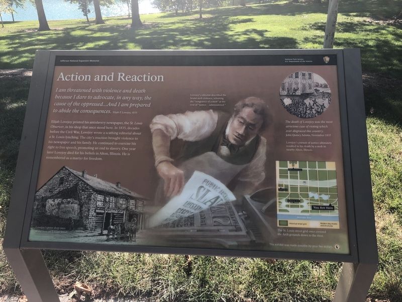
I am threatened with violence and death because I dare to advocate, in any way, the cause of the oppressed…And I am prepared to abide the consequences. Elijah P. Lovejoy, 1835
Elijah Lovejoy printed his antislavery newspaper, the St. Louis Observer, in his stop that once stood here. In 1835, decades before the Civil War, Lovejoy wrote a scathing editorial about a St. Louis lynching. The city's reaction brought violence to his newspaper and his family. He continued to exercise his right to free speech, promoting an end to slavery. One year later Lovejoy died for his beliefs in Alton, Illinois. He is remembered as a martyr for freedom.
[Captions:]
Lovejoy's editorial described the brutal mob violence, rebuking the "vengeance of a mob" at the cost of "justice…administered."
The death of Lovejoy was the most atrocious case of rioting which ever disgraced this country.
John Quincy Adams, November 1837
[Captions:]
Lovejoy's pursuit of justice ultimately resulted in his death by a mob in nearby Alton, Illinois.
The St. Louis street grid once covered the Arch ground down to the river.
Erected by National
this page online
Topics and series. This historical marker is listed in these topic lists: Abolition & Underground RR • Communications. In addition, it is included in the Former U.S. Presidents: #06 John Quincy Adams series list. A significant historical month for this entry is November 1837.
Location. 38° 37.664′ N, 90° 11.039′ W. Marker is in St. Louis, Missouri. It is in Downtown. It is on Gateway Arch Trail, on the right when traveling south. Touch for map. Marker is in this post office area: Saint Louis MO 63102, United States of America. Touch for directions.

Regionally, this marker is in the American Midwest, in the Lewis & Clark Corridor, in the Corn Belt, and in the Great River Road Region. Globally, it is in North America, the Western Hemisphere, the Western World, and the Anglosphere. Historically, it finds itself in what was once the territory of the Mississippian Culture, the Louisiana Purchase, and the Antebellum South.
Other nearby markers. At least 8 other markers are within walking distance of this marker: Gateway to the West (within shouting distance of this marker); Speedy Delivery
Another marker is no longer nearby. Lewis and Clark and St. Louis Riverfront (was about 700 feet away but has been confirmed missing).
Credits. This page was last revised on January 30, 2023. It was originally submitted on September 17, 2019, by Devry Becker Jones of Washington, District of Columbia. This page has been viewed 478 times since then and 30 times this year. Photos: 1, 2. submitted on September 17, 2019, by Devry Becker Jones of Washington, District of Columbia.
