Near Xenia in Greene County, Ohio — The American Midwest (Great Lakes)
Collins School
Photographed by William Fischer, Jr., November 14, 2008
1. Collins School Marker
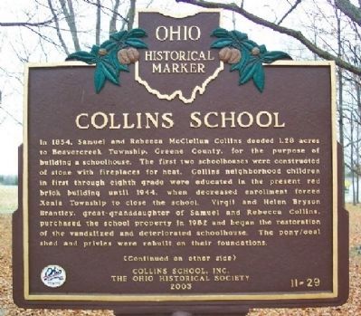
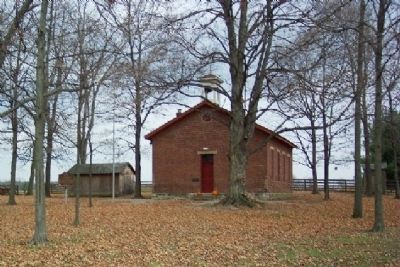
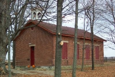
In 1854, Samuel and Rebecca McClellan Collins deeded 1.28 acres to Beavercreek Township, Greene County, for the purpose of building a schoolhouse. The first two schoolhouses were constructed of stone with fireplaces for heat. Collins neighborhood children in first through eighth grade were educated in the present red brick building until 1944, when decreased enrollment forced Xenia Township to close the school. Virgil and Helen Bryson Brantley, great-granddaughter of Samuel and Rebecca Collins, purchased the school property in 1982 and began the restoration of the vandalized and deteriorated schoolhouse. The pony/coal shed and privies were rebuilt on their foundations.
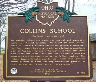
The Brantleys enlisted two teachers to research and organize a curriculum of rural education. On August 30, 1986, Collins School was formally “re-dedicated for the purpose of education.” That fall, students from area schools were invited to experience a day of “readin’, ritin’ and ’rithmetic” as it would have taken place in the late 1800s. Each year, nearly 2,400 children and adults enjoy this opportunity led by the Collins’ teachers. The students learn
this page online
Erected 2003 by Collins School, Inc. and The Ohio Historical Society. (Marker Number 11-29.)
Topics and series. This historical marker is listed in these topic lists: Education • Notable Buildings. In addition, it is included in the Ohio Historical Society / The Ohio History Connection series list. A significant historical year for this entry is 1854.
Location. 39° 45.961′ N, 83° 56.882′ W. Marker is near Xenia, Ohio, in Greene County. It is on Enon Road 0.1 miles north of Ohio Route 235, on the right when traveling north. Collins School is about two miles north of Oldtown. Touch for map. Marker is at or near this postal address: 2810 W Enon Road, Xenia OH 45385, United States of America. Touch for directions.

Regionally, this marker is in Ohio’s Dayton Metro and in the Miami Valley. It is also in the American Midwest and in the Corn Belt. Globally, it is in North America, the Western Hemisphere, the Western World, and the Anglosphere. Historically,
Photographed by William Fischer, Jr., November 14, 2008
2. Collins School Marker Reverse
Other nearby markers. At least 8 other markers are within 3 miles of this marker, measured as the crow flies: Blackfish Trail (approx. 2.6 miles away); Discover (approx. 2.6 miles away); The Ohio Country / Old Chillicothe (approx. 2.6 miles away); Welcome (approx. 2.6 miles away); Old Chillicothe (approx. 2.6 miles away); Daniel Boone Memorial (approx. 2.6 miles away); a different marker also named Daniel Boone Memorial (approx. 2.6 miles away); a different marker also named Old Chillicothe (approx. 2.6 miles away).
Additional commentary.
1. Private property
This marker is on private property. Please respect the owner's privacy and only access the site with permission. Note To Editor only visible by Contributor and editor
— Submitted July 28, 2021, by Robert Baughman of Bellefontaine, Ohio.

Photographed by William Fischer, Jr., November 14, 2008
3. Collins School Marker
Restored by Virgil & Helen Bryson Brantley
Rededicated for Education August 30, 1986
Given by their family
Photographed by William Fischer, Jr., November 14, 2008
4. Collins School and Marker
Photographed by William Fischer, Jr., November 14, 2008
5. Collins School
Family marker next to door

Photographed by Craig Doda, October 4, 2025
6. Collins School Marker
Credits. This page was last revised on October 10, 2025. It was originally submitted on December 2, 2008, by William Fischer, Jr. of Reynoldsburg, Ohio. This page has been viewed 4,695 times since then and 158 times this year. Photos: 1, 2, 3, 4, 5. submitted on December 2, 2008, by William Fischer, Jr. of Reynoldsburg, Ohio. 6. submitted on October 8, 2025, by Craig Doda of Napoleon, Ohio. • Kevin W. was the editor who published this page.
