Strathmore in Tulare County, California — The American West (Pacific Coastal)
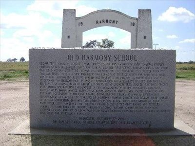
Old Harmony School
Inscription.
The original Harmony School opened August 5, 1871, was among the first to serve pioneer families who settled west along the Tule River. The first school building was a one-room one-sided wooden structure. It was located some 100 feet south of this corner near the two oak trees. In 1918 a new two-room structure was built of which the remaining arch was a part. Among the families served was that of Julius Orton, a Forty-Niner and a veteran of the Mexican War. In 1857 he homesteaded 160 acres east of here and brought his family and small herd of cattle 230 miles cross country from Soquel. The David McGees were among the earliest landowners in the area, along with the Hunsakers, Callisons, Kirbys, Yavers, Roths, Lewises, Monroe, Spuhlers, Vosslers and Stones. Cattle ranching was the main occupation in the lush prairie between Four Creeks and White River, where filagree grew as high as the stirrups of a saddle. Floods, drought, disease were threats. In the 1877 diphtheria epidemic, two children in the Blair family died within an hour of each other. The "No Fence Law" of 1877 curtailed use of the open range and settlers turned to other forms of farming. Harmon became a part of the Sunnyside District in 1945. The 1918 building was used as a community center until it burned on July 27, 1983. Only the arch remains.
Erected 1994 by Dr. Samuel Gregg George Chapter 1855 of E Clampus Vitus.
Topics and series. This historical marker is listed in these topic lists: Education • War, Mexican-American. In addition, it is included in the E Clampus Vitus series list. A significant historical date for this entry is July 27, 1871.
Location. 36° 7.409′ N, 119° 10.159′ W. Marker is in Strathmore, California, in Tulare County. Marker is at the intersection of Welcome Avenue and Road 180, on the left when traveling west on Welcome Avenue. Touch for map. Marker is at or near this postal address: 18001-18385 Avenue 184, Strathmore CA 93267, United States of America. Touch for directions.
Other nearby markers. At least 8 other markers are within 9 miles of this marker, measured as the crow flies. Rankin Aeronautical Academy (approx. 5.3 miles away); Roth's Spur (approx. 6 miles away); Cairns Corner Olive Trees (approx. 6.3 miles away); Butterfield Overland Mail Route (approx. 6.6 miles away); Fremont Trail (approx. 6.6 miles away); Porterville Area Vietnam Memorial (approx. 7.3 miles away); First Burton Schoolhouse (approx. 8 miles away); Tule River Stage Station (approx. 8.9 miles away).
Credits. This page was last revised on November 2, 2019. It was originally submitted on October 27, 2019, by Frank Gunshow Sanchez of Hollister, California. This page has been viewed 624 times since then and 76 times this year. Photo 1. submitted on October 27, 2019, by Frank Gunshow Sanchez of Hollister, California. • J. Makali Bruton was the editor who published this page.
Editor’s want-list for this marker. A clear and completely readable photo of the marker. • Can you help?
