Porterville in Tulare County, California — The American West (Pacific Coastal)
First Burton Schoolhouse
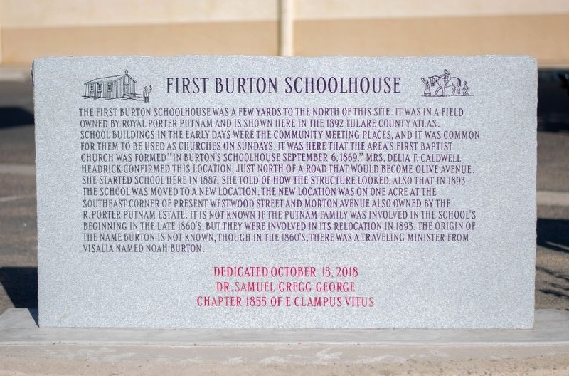
Photographed by Dr. Samuel Gregg George Chapter No. 1855 E Clampus Vitus, October 13, 2018
1. First Burton Schoolhouse Marker
School buildings in the early days were the community meeting places, and it was common for them to be used as churches on Sundays. It was here that the area's first Baptist Church was formed in "Burton's Schoolhouse September 6,1869." Mrs. Delia F. Caldwell Headrick confirmed this location, just North of a road that would become Olive Avenue.
She started school here in 1887. She told of how the structure looked, also that in 1893 the school was moved to a new location. The new location was on one acre at the Southeast corner of present Westwood Street and Morton Avenue also owned by the R. Porter Putnam Estate. It is not known if the Putnam family was involved in the school's beginning in the late 1860's, but they were involved in its relocation in 1893. The origin of the name Burton is not known, though in the 1860's, there was a traveling minister from Visalia named Noah Burton.
Erected 2018 by Dr. Samuel Gregg George Chapter 1855 of E Clampus
this page online
Topics and series. This historical marker is listed in this topic list: Education. In addition, it is included in the E Clampus Vitus series list. A significant historical date for this entry is September 6, 1869.
Location. 36° 3.961′ N, 119° 2.688′ W. Marker is in Porterville, California, in Tulare County. It is at the intersection of Olive Avenue and North Dameron Street, on the right when traveling west on Olive Avenue. Touch for map. Marker is at or near this postal address: 1236 West Olive Street, Porterville CA 93257, United States of America. Touch for directions.

Regionally, this marker is in California’s San Joaquin Valley, specifically in the Central Valley, and in the Sierra Nevada. It is also on the American Pacific Coast. Globally, it is in North America, on the Ring of Fire, on the Pacific Rim, in the Western Hemisphere, in the Western World, and in the Anglosphere. Historically, it finds itself in what was once New Spain and also Mexico’s Alta California.
Other nearby markers. At least 8 other markers are within 2 miles of this marker, measured as the crow flies: Porterville Area Vietnam Memorial (approx. one mile away); Porterville's Badman (approx. 1.6 miles away); Time Marches On (approx. 1.6 miles away); Tule River Stage Station (approx. 1.7 miles away); Nettie Smith's Place (approx. 1.7 miles away); Elisha Packwood (approx. 1.7 miles away); Dr. Samuel Gregg George (approx. 1.8 miles away); Gabriel Moraga (approx. 2.1 miles away). Touch for a list and map of all markers in Porterville.
Also see . . . News article on the Burton Schoolhouse. (Submitted on October 30, 2019, by Frank Gunshow Sanchez of Hollister, California.)
Credits. This page was last revised on November 2, 2019. It was originally submitted on October 30, 2019, by Frank Gunshow Sanchez of Hollister, California. This page has been viewed 722 times since then and 32 times this year. Photo 1. submitted on October 30, 2019, by Frank Gunshow Sanchez of Hollister, California. • Syd Whittle was the editor who published this page.
Editor’s want-list for this marker. Wide area view of the markers and its surroundings. • Can you help?
