The New Framework of Government
Oklahoma City May-August, 1890
— The ‘89er Trail —
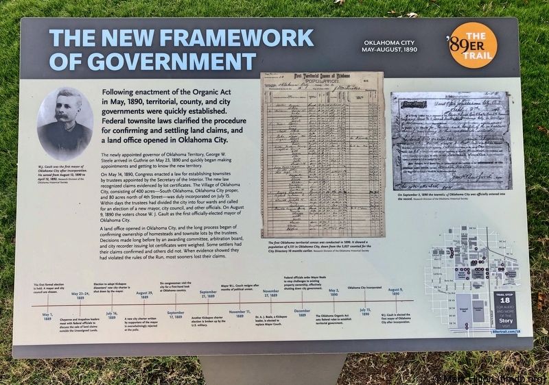
Following enactment of the Organic Act in May, 1890, territorial, county, and city governments were quickly established. Federal townsite laws clarified the procedure for confirming and settling land claims, and a land office opened in Oklahoma City.
The newly appointed governor of Oklahoma Territory, George W. Steele arrived in Guthrie on May 23, 1890 and quickly began making appointments and getting to know the new territory.
On May 14, 1890, Congress enacted a law for establishing townsites by trustees appointed by the Secretary of the Interior. The new law recognized claims evidenced by lot certificates. The Village of Oklahoma City, consisting of 400 acres - South Oklahoma, Oklahoma City proper, and 80 acres north of 4th Street - was duly incorporated on July 15. Within days the trustees had divided the city into four wards and called for an election of a new mayor, city council, and other officials. On August 9, 1890 the voters chose W. J. Gault as the first officially-elected mayor of Oklahoma City.
A land office opened in Oklahoma City, and the long process began of confirming ownership of homesteads and townsite lots by the trustees. Decisions made long before by an awarding committee, arbitration board, and city recorder issuing lot certificates were weighed. Some settlers had their claims confirmed
and others did not. When evidence showed they had violated the rules of the Run, most sooners lost their claims.
Photo captions:
Top left: W.J. Gault was the first mayor of Oklahoma City after incorporation. He served from August 12, 1890 to April 12, 1892.
Research Division of the Oklahoma Historical Society
Middle: The first Oklahoma territorial census was conducted in 1890. It showed a population of 4,151 in Oklahoma City, down from the 5,027 counted for the City Directory 10 months earlier. Research Division of the Oklahoma Historical Society
Top right: On September 3, 1890 the townsite of Oklahoma City was officially entered into the record. Research Division of the Oklahoma Historical Society
Erected 2018 by Oklahoma City Community Foundation, Wiggin Properties. (Marker Number 18.)
Topics and series. This historical marker is listed in these topic lists: Government & Politics • Settlements & Settlers. In addition, it is included in the The '89er Trail series list. A significant historical month for this entry is May 1890.
Location. 35° 28.144′ N, 97° 31.201′ W. Marker is in Oklahoma City, Oklahoma, in
Other nearby markers. At least 8 other markers are within walking distance of this marker. Prominent Land Cases (a few steps from this marker); The Oklahoma Territory Organic Act (within shouting distance of this marker); Beale Defeats Overholser For Mayor (within shouting distance of this marker); The Resignation of Mayor William L. Couch (approx. 0.2 miles away); T.M. Richardson and the Oklahoma Bank (approx. ¼ mile away); Henry Overholser (approx. ¼ mile away); Charles Colcord (approx. ¼ mile away); Team Effort (approx. ¼ mile away). Touch for a list and map of all markers in Oklahoma City.
Credits. This page was last revised on February 16, 2023. It was originally submitted on November 1, 2019, by Mark Hilton of Montgomery, Alabama. This page has been viewed 116 times since then and 19 times this year. Photos: 1, 2. submitted on November 1, 2019, by Mark Hilton of Montgomery, Alabama.

