Marker Logo
THE HISTORICAL
MARKER DATABASE
“Bite-Size Bits of Local, National, and Global History”
Lewistown in Fergus County, Montana — The American West (Mountains)
 

Hopkins Grocery

Lewistown Central Business Historic District
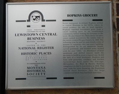
 
 
Hopkins Grocery Marker image. Click for full size.
Photographed by Barry Swackhamer, August 17, 2019
1. Hopkins Grocery Marker
Inscription. Welsh immigrant Archibald Hopkins settled in central Montana in the 1870s, where he raised produce for sale to local markets. Hopkins watched Lewistown grow from a small trading post to an established community before linking his fortunes to the town. He purchased this Main Street lot after voters named Lewistown the county seat of the newly created Fergus County in 1899. The following year he and his sons hired a crew of masons to construct this one-story building, distinguished by its cut sandstone faηade, curved pediment, and dressed stone incised with the year "1900." An abundance of local sandstone and skilled masons made the decision to build in stone a logical one. So did the lack of a local brickyard. Hopkins and Sons sold groceries, crockery, and kitchen furnishing here until the Chicago, Milwaukee, St. Paul and Pacific Railway completed its line to Lewistown in 1908. That year, with the town booming, the Hopkinses moved their business into the large commercial block they had built next door.
 
Erected by The Montana National Register Sign Program.
 
Topics and series. This historical marker is listed in
Paid Advertisement
Click or scan to see
this page online
these topic lists: ArchitectureIndustry & CommerceSettlements & Settlers. In addition, it is included in the Montana National Register Sign Program series list.
 
Location. 47° 3.981′ N, 109° 25.464′ W. Marker is in Lewistown, Montana, in Fergus County. It is on West Main Street (U.S. 87) near 2nd Avenue South, on the left when traveling west. Touch for map. Marker is at or near this postal address: 117 West Main Street, Lewistown MT 59457, United States of America. Touch for directions.

Regionally, this marker is in andspecifically entral Montana in Russell Country. It is also in the American Mountain West and in the Lewis & Clark Corridor. Globally, it is in North America, the Western Hemisphere, the Western World, and the Anglosphere. Historically, it finds itself in what was once Rupert’s Land and also the Louisiana Purchase.

Other nearby markers. At least 8 other markers are within walking distance of this marker: Knerr-Tubb Block / Armory Hall (within shouting distance of this marker); Mackey Building (Montana Tavern) (within shouting distance of this marker);
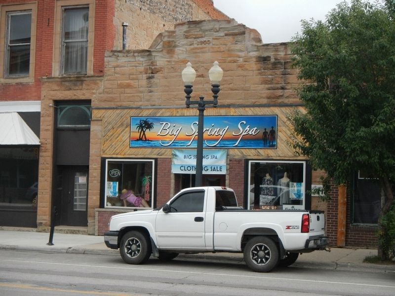
Hopkins Grocery and Marker image. Click for full size.
Photographed by Barry Swackhamer, August 17, 2019
2. Hopkins Grocery and Marker
The marker is above the pick-up truck tailgate.
The Hub (about 300 feet away, measured in a direct line); Warr Building (about 300 feet away); US Land Office / Warr Building (about 300 feet away); Saint Leo's Catholic Church (about 400 feet away); Bank of Fergus County (about 400 feet away); Montana Building (about 400 feet away). Touch for a list and map of all markers in Lewistown.
 
 
Credits. This page was last revised on December 19, 2020. It was originally submitted on December 12, 2019, by Barry Swackhamer of Brentwood, California. This page has been viewed 249 times since then and 12 times this year. Photos:   1, 2. submitted on December 12, 2019, by Barry Swackhamer of Brentwood, California.

m=143458

CeraNet Cloud Computing sponsors the Historical Marker Database.
This website earns income from purchases you make after using our links to Amazon.com. We appreciate your support.
Paid Advertisement
Jul. 23, 2026