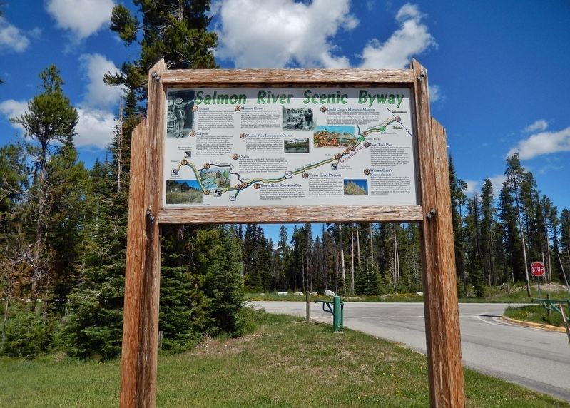
Near Sula in Ravalli County, Montana — The American West (Mountains)
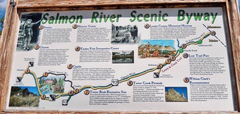
Salmon River Scenic Byway
1 • Stanley
Fur trappers from the Hudson’s Bay Company were the first to discover Stanley Basin during 1824. Stanley was named for Captain John Stanley, a Civil War veteran who brought 23 prospectors into the basin searching for gold. Unfortunately, only small amounts of placer gold were found in the streams. Searching further, the prospectors moved to the Middle Fork of the Boise River where, they discovered the Atlanta lode.
2 • Historic Custer
The General Custer, one of Idaho's significant mining claims was named during 1876 to honor Civil War General George Armstrong Custer. The towns of Custer and Bonanza were established in 1879 to support the General Custer, the Charles Dickens, and the Lucky Boy along with other mines in the Yankee Fork Mining District. Today, historic buildings along with mining artifacts are preserved at Custer which is open to tours during the summer.
3 • Clayton
Clayton's frontier history dates back more than 100 years when it became home to southern Idaho's largest silver producing area. The Idaho Mining and Smelter Company Store built in 1880 today serves as Clayton's museum showcasing the local mining, ranching, and logging history. A blacksmith shop and livery along with early farming memorabilia offer a glimpse back in time to what life was like in Idaho's mountains during the 1880s.
4 • Yankee Fork Interpretive Center
Land of the Yankee Fork Interpretive Center commemorates Idaho's frontier mining history. Experience a trail of discovery back in time with audiovisual programs and mining displays from Idaho's Land of the Yankee Fork Historic Area. The center is operated by Idaho Department of Parks and Recreation and is open year round.
5 • Challis
Challis was named after Alvah P. Challis who surveyed the mile-high town in 1879. Searching for beaver during 1822, the first white man to arrive in the territory was Michel Bourdon of the Hudson's Bay Company. The region's mineral riches brought early pioneers to prospect and farm the high mountain desert. Today, Challis is a paradise for outdoor recreation, and serves as the gateway to the Salmon River Country.
6 • Lemhi County Historical Museum
The Lemhi County Museum houses an extensive collection of Lemhi Shoshone artifacts. Clothing, beadwork, arrowheads, and ceremonial accessories, as well as photographs, showcase the Shoshone people's lives in the Lemhi and Salmon River Valleys. The discovery of gold during 1866 in the mountains above the city of Salmon introduced a new era of history. Displays of historical implements and photographs illustrate Salmon's early mining history.
7 • Tower Rock Recreation Site
Tower Rock Recreation Site, a BLM Campground, is located 11 miles north of Salmon on US 93. A detachment led by William Clark camped here on August 21 and 25, 1805 while completing the reconnaissance of the Salmon River. Interpretive panels highlight the geology of Tower Rock and Clark's campsite.
8 • Tower Creek Pirimids
The Lewis and Clark expedition traveled up Tower Creek on August 31st 1805. Clark recorded, "...passed remarkable rock resembling pirimids on the left side." The day use site includes picnic tables and an historic homesteader's cabin. Information panels interpret the geology of the "pirimids," along with the Corps of Discovery's departure from Lemhi County.
9 • William Clark's Reconnaissance
William Clark turned west along the Salmon River at this point to consider a water route through the mountains. About 12 miles from here, Clark looked out over the Salmon River on August 22nd 1805 and determined that the river route was impassable. Clark returned to meet Lewis at the Shoshone camp along the Lemhi River on August 27, 1805. A three panel interpretive kiosk tells the story of the Down River Reconnaissance.
10 • Lost Trail Pass
The Corps of Discovery camped two miles west of this location the night of September 3rd 1805. With winter quickly approaching, the Corps decided to forge a trail north through the thickets and over the stony hills of Lost Trail Pass. The expedition proceeded to the Bitterroot Valley and back into Idaho by way of the Lolo Trail. Interpretive signs of the Lewis & Clark Expedition through Idaho are on display at The Lost Trail Pass Visitor Information Center.
Topics. This historical marker is listed in these topic lists: Exploration • Industry & Commerce • Native Americans • Settlements & Settlers.
Location. 45° 41.626′ N, 113° 56.982′ W. Marker is near Sula, Montana, in Ravalli County. Marker can be reached from Lost Trail Ski Area (Forest Road 081) just west of Casey Road (U.S. 93), on the left when traveling north. Touch for map. Marker is at or near this postal address: 9485 US Highway 93, Sula MT 59871, United States of America. Touch for directions.
Other nearby markers. At least 8 other markers are within 10 miles of this marker, measured as the crow flies. Which Way Did Lewis & Clark Go? (within shouting distance of this marker); Jerry Fahey’s Cutoff (approx. 0.8 miles away in Idaho); Lost Trail Pass (approx. 0.8 miles away in Idaho); Lewis and Clark (approx. 2.7 miles away in Idaho); Deep Creek (approx. 7 miles away in Idaho); Natural Travel Corridor (approx. 7 miles away); A Story of Fires... to be continued (approx. 8.6 miles away); Join the Voyage of Discovery (approx. 10 miles away). Touch for a list and map of all markers in Sula.
Also see . . . Salmon River Scenic Byway. The Salmon River Scenic Byway begins near the Montana border at the 6,995-foot-high Lost Trail Pass. Lewis and Clark were forced to come this way in 1805 when their native guide lost the trail. This route to Stanley follows the Salmon River through the Salmon and Challis National Forests. (Submitted on January 5, 2020, by Cosmos Mariner of Cape Canaveral, Florida.)
Credits. This page was last revised on January 5, 2020. It was originally submitted on January 5, 2020, by Cosmos Mariner of Cape Canaveral, Florida. This page has been viewed 357 times since then and 49 times this year. Photos: 1, 2. submitted on January 5, 2020, by Cosmos Mariner of Cape Canaveral, Florida.

