Oella in Baltimore County, Maryland — The American Northeast (Mid-Atlantic)
Edges of Earth's Crust Collided Here
... in the Patapsco Heritage Area

Photographed By Devry Becker Jones (CC0), January 19, 2020
1. Edges of Earth's Crust Collided Here Marker
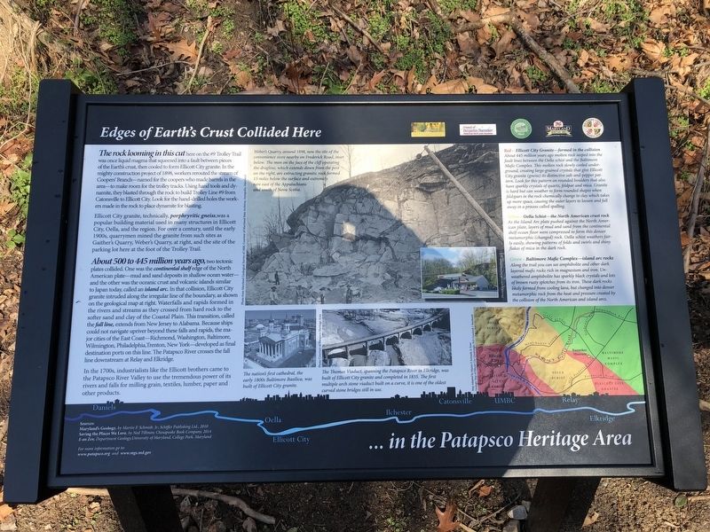
Ellicott City granite, technically, porphryritic gneiss, was a popular building material used in many structures in Ellicott City, Oella, and the region. For over a century, until the early 1900s, qurrymen mined the granite from such sites as Gaither's Quarry, Weber's Quarry, at right, and the site of the parking lot here at the foot of the Trolley Trail.
About 500 to 445 millions years ago, two tectonic plates collided. One was the continental shelf edge of the North American plate—mud and sand deposits in shallow ocean water—and the other was the oceanic crust and volcanic islands similar to Japan today, called an island arc. In that collision, Ellicott City granite intruded along the irregular line of the boundary, as shown on the geological map at right. Waterfalls and rapids formed in the rivers and streams as they crossed from hard rock to the softer sand and clay of the Coastal Plain. This transition, called the fall line, extends from New Jersey to Alabama. Because ships could not navigate upriver beyond these falls and rapids, the major cities of the East Coast—Richmond, Washington, Baltimore, Wilmington, Philadelphia, Trenton, New York—developed as final destination ports on this line. The Patapsco River crosses the fall line downstream at Relay and Elkridge.
In the 1700s, industrialists like the Ellicott brothers came to the Patapsco River Valley to use the tremendous power of its rivers and falls for milling grain, textiles, lumber, paper and other products.
[Captions:]
Weber's Quarry, around 1898, now the site of the convenience store nearby on Frederick Road, inset below. The men on the face of the cliff operating the dragline, which extends down from the post on the right, are extracting granitic rock formed 15 miles below the surface and extremely rare east of the Appalachians and south of Nova Scotia.
The nation's first cathedral, the early 1800s Baltimore Basilica, was built of Ellicott City granite.
The Thomas Viaduct,

Photographed By Devry Becker Jones (CC0), January 19, 2020
2. Edges of Earth's Crust Collided Here Marker
Erected by Oella Historical Society, Friends of Benjamin Banneker Historical Park and Museum; Patapsco Valley Heritage Greenway; Maryland Heritage Area Authority; Baltimore County, Maryland.
Topics. This historical marker is listed in these topic lists: Architecture • Bridges & Viaducts • Churches & Religion • Environment • Industry & Commerce • Railroads & Streetcars. A significant historical year for this entry is 1898.
Location. 39° 16.094′ N, 76° 47.536′ W. Marker is in Oella, Maryland, in Baltimore County. Marker can be reached from Westchester Avenue, 0.1 miles east of Frederick Road (Maryland Route 144), on the left when traveling east. Touch for map. Marker is at or near this postal address: 3003 Westchester Avenue, Ellicott City MD 21043, United States of America. Touch for directions.
Other nearby markers. At least 8 other markers are within walking distance of this marker. "Just One Nickel and I Could Ride" (about 300 feet away, measured in a direct line); The George Ellicott House (about 300 feet away); Up This Winding Road Lies the Village of Oella (about 400 feet away); Oella (about 400 feet away); Ellicott’s Mills (about 500 feet away); Baltimore and Frederick Turnpike Milestone (about 800 feet away); Roads versus Rails (about 800 feet away); Turntable & Track (approx. 0.2 miles away). Touch for a list and map of all markers in Oella.
Credits. This page was last revised on January 19, 2020. It was originally submitted on January 19, 2020, by Devry Becker Jones of Washington, District of Columbia. This page has been viewed 342 times since then and 48 times this year. Photos: 1, 2. submitted on January 19, 2020, by Devry Becker Jones of Washington, District of Columbia.