Near Texico in Curry County, New Mexico — The American Mountains (Southwest)
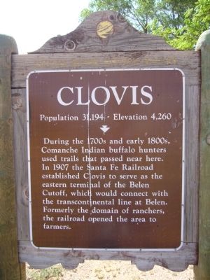
Clovis
Population 31,194 -- Elevation 4,260
Erected by New Mexico Historic Preservation Division.
Topics. This historical marker is listed in these topic lists: Native Americans • Railroads & Streetcars • Settlements & Settlers. A significant historical year for this entry is 1907.
Location. Marker has been reported missing. It was located near 34° 23.427′ N, 103° 4.755′ W. Marker was near Texico, New Mexico, in Curry County. Marker was on U.S. 60, on the right when traveling west. Marker is in the southeast corner of the New Mexico visitor center, about 2.3 miles west of the Texas border. Touch for map. Marker was in this post office area: Texico NM 88135, United States of America. Touch for directions.
Other nearby markers. At least 8 other markers are within 14 miles of this location, measured as the crow flies. Farwell, Texas (approx. 2.3 miles away in Texas); Near Route of the Coronado Expedition (approx. 2.3 miles away in Texas); Parmer County (approx. 2.3 miles away in Texas); Hopping-Aldridge House (approx. 2.4 miles away in Texas); Olivet Cemetery (approx. 3˝ miles away in Texas); Norman Petty Studios (approx. 8.2 miles away); Oklahoma Lane (approx. 11.3 miles away in Texas); Blackwater Draw (approx. 13.8 miles away).
Additional commentary.
1. Missing Marker
It has been reported that the marker was originally located at a visitor center parking lot. That center has been demolished and the marker was removed.
— Submitted February 2, 2020, by Syd Whittle of Mesa, Arizona.
Credits. This page was last revised on February 2, 2020. It was originally submitted on June 7, 2012, by Bill Kirchner of Tucson, Arizona. This page has been viewed 1,175 times since then and 36 times this year. Last updated on February 1, 2020, by Sandy Ballard of Albuquerque, New Mexico. Photos: 1, 2, 3. submitted on June 7, 2012, by Bill Kirchner of Tucson, Arizona. • Syd Whittle was the editor who published this page.


