El Capulín in San José Iturbide, Guanajuato, Mexico — The Central Highlands (North America)
Porfirio Vega Guerrero
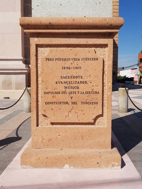
Photographed by J. Makali Bruton, February 15, 2020
1. Porfirio Vega Guerrero Marker

1898-1966
Sacerdote
Evangelizador
Musico
Impulsor del arte y la cultura y
Constructor del progreso
Nacio el 15 de IX de 1898
Ordenado sacerdote 19 de II de 1928
Parroco del 29 de VII de 1933 a 12 de XII de 1965
Murio el 12 de XII de 1965
Parroquia de los Siete Dolores de Maria Santisima
El Capulin Gto.
Por su L Aniversario Luctuoso
Siendo IX Opispo de la Diocesis de Queretaro, Mons. Faustino Armendariz Jimenez
Parroco Enrique Ugalde
Vicario Baltasar Resendiz Espindola
12 de diciembre de 2015
Presbyter Porfirio Vega Guerrero
1898-1966
Priest · Evangelizer · Musician · Promoter of art and culture and a Builder of progress
Born on September 15, 1898
Ordained priest on February 19, 1928
Parish priest from July 29, 1933 to December 12, 1965
He died on December 12, 1965
Parish of the Seven Sorrows of the Most Holy Mary
El Capulin, Guanajuato
This monument placed on the 50th Anniversary of this death
By the 9th Bishop of the Diocese of Queretaro, Msgr. Faustino Armendariz Jimenez
Parish Priest Enrique Ugalde
Vicar Baltasar Resendiz Espindola
December 12, 2015
Erected 2015.
this page online
Topics. This historical marker is listed in these topic lists: Charity & Public Work • Religion & Religious Structures. A significant historical date for this entry is February 19, 1928.
Location. 21° 2.484′ N, 100° 19.26′ W. Marker is in El Capulín, Guanajuato, in San José Iturbide. It is at the intersection of Calle Ignacio Zaragoza and Avenida Hidalgo, on the right when traveling south on Calle Ignacio Zaragoza. Touch for map. Marker is in this post office area: El Capulín GTO 38653, Mexico. Touch for directions.

Regionally, this marker is in Central Mexico and in the Bajío. Globally, it is in North America, on the Ring of Fire, and in the Western Hemisphere. Historically, it finds itself in what was once New Spain, a Spanish colony, and the Aztec Empire.
Other nearby markers. At least 8 other markers are within 21 kilometers of this marker, measured as the crow flies: To the Liberator Agustín Iturbide (approx. 8.1 kilometers away); History of the City of San José Iturbide, Guanajuato (approx. 8.2 kilometers away); Plaza of the Constituent Congress of 1917 (approx. 8.6 kilometers away); Fiftieth Anniversary of the Foundation of the Municipality of Dr. Mora

Photographed by J. Makali Bruton
2. Porfirio Vega Guerrero Marker

Photographed by J. Makali Bruton, February 15, 2020
3. Porfirio Vega Guerrero Marker

Photographed by J. Makali Bruton, February 15, 2020
4. Porfirio Vega Guerrero statue

Photographed by J. Makali Bruton, February 15, 2020
5. An interior view of the Parish of the Siete Dolores de María Santísima

Photographed by J. Makali Bruton, February 15, 2020
6. The interior dome of the Parish of the Siete Dolores de María Santísima
Credits. This page was last revised on March 15, 2020. It was originally submitted on March 14, 2020, by J. Makali Bruton of Washington, District of Columbia. This page has been viewed 353 times since then and 43 times this year. Photos: 1. submitted on March 14, 2020, by J. Makali Bruton of Washington, District of Columbia. 2, 3, 4, 5, 6. submitted on March 15, 2020, by J. Makali Bruton of Washington, District of Columbia.
