Tahawus in Essex County, New York — The American Northeast (Mid-Atlantic)
Adirondac
1826-1858
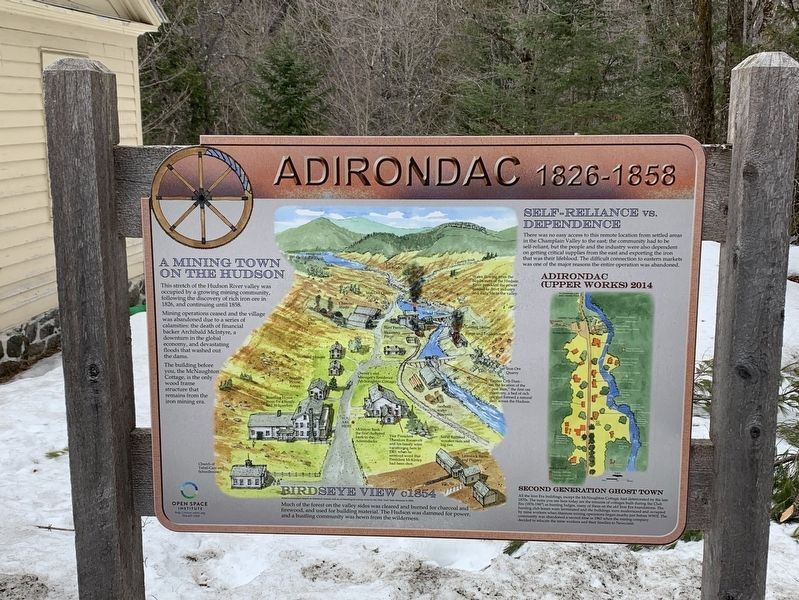
Photographed by Steve Stoessel, March 28, 2020
1. Adirondac Marker
A Mining Town On The Hudson
This stretch of the Hudson River valley was occupied by a growing mining community, following the discovery of rich iron ore in 1826, and continuing until 1858.
Mining operations ceased and the village was abandoned due to a series of calamities: the death of financial backer Archibald McIntyre, a downturn in the global economy, and devastating floods that washed out the dams.
The building before you, the McNaughton Cottage, is the only wood frame structure that remains from the iron mining era.
Birdseye View c. 1854
Art's conception based on historical records and an archeological survey done by the New Yok State Museum in 2004. Much of the forest on the valley sides was cleared and burned for charcoal and firewood, and used for building material. The Hudson was dammed for power, and a bustling community was hewn from the wilderness.
Self-Reliance Vs. Dependence
There was no easy access to this remote location from settled areas in the Champlain Valley to the east; the community had to be self-reliant, but the people and the industry were also dependent on getting critical
this page online
Second Generation Ghost Town
All the Iron Era buildings, except the McNaughton Cottage, had deteriorated by the late 1870s. The ruins you see here today are the remains of cottages built during the Club Era (1876-1947) as hunting lodges, many of them on the old Iron Era foundations. The hunting club leases were terminated and the buildings were modernized and occupied by mine workers when titanium mining operations began nearby just before WWII. The community was abandoned a second time in 1963 when the mining company decided to relocate the mine workers and their families to Newcomb.
Map Features
Water flowing from the headwaters of the Hudson River provided the power needed to drive industry and daily life in the valley.
Timber Crib Dam- on the location of the iron dam,” the first ore discovery, a bed of rich ore that formed a natural dam across the Hudson.
Owner’s and Manager's Residence McNaughton Cottage
Vice President Theodore Roosevelt and his family were vacationing here in 1901 when he received word that President McKinley had been shot
McIntyre Bank- the first chartered bank-in the Adirondacks.
Erected by Open Space Institute.
Topics and series. This historical marker is listed in this topic list: Settlements & Settlers. In addition, it is included in the Former U.S. Presidents: #25 William McKinley, and the Former U.S. Presidents: #26 Theodore Roosevelt series lists. A significant historical year for this entry is 1826.
Location. 44° 5.199′ N, 74° 3.354′ W. Marker is in Tahawus, New York, in Essex County. It is on Upper Works Road (County Route 25) 9.7 miles north of Blue Ridge Road, on the right when traveling north. Touch for map. Marker is in this post office area: Newcomb NY 12879, United States of America. Touch for directions.

Regionally, this marker is in Upstate New York, in the Adirondacks & North Country, and in the Champlain Valley. It is also in the American Northeast and in the Mid-Atlantic. Globally, it is in North America, the Great North Woods, the Western Hemisphere, the Western World, and the Anglosphere. Historically, it finds itself in what was once the Viceroyalty of New France, New Netherland, and one of the original Thirteen Colonies.
Other nearby markers. At least 8 other markers are within walking distance of this marker: MacNaughton Cottage (a few steps from this marker); Tahawus Clubhouse (a few steps from this marker); The Club Era (within shouting distance of this marker); An Abundance of Ore (within shouting distance of this marker); Abbott/Lockwood (within shouting distance of this marker); Three Communities (within shouting distance of this marker); Taming the Wilderness (about 300 feet away, measured in a direct line); Lazy Lodge (about 300 feet away). Touch for a list and map of all markers in Tahawus.
Also see . . . Open Space Institute. (Submitted on April 6, 2020, by Michael Herrick of Southbury, Connecticut.)
Credits. This page was last revised on August 1, 2020. It was originally submitted on April 2, 2020, by Steve Stoessel of Niskayuna, New York. This page has been viewed 278 times since then and 14 times this year. Photo 1. submitted on April 2, 2020, by Steve Stoessel of Niskayuna, New York. • Michael Herrick was the editor who published this page.
Editor’s want-list for this marker. A wide angle photo of the marker and its surroundings. • Can you help?
